Hi! You know the drill - latest entries at the top, oldest at the bottom. It's best to go to the bottom and scroll your way to the top. Enjoy! It was another gloomy day with intermittent rain so as we neared Denali National Park we realized we probably wouldn't get a great view Mount McKinley (now known as Mount Denali). We did manage to get this shot from Denali Viewpoint North, but hoped we'd have better luck at viewpoints further south. We couldn't believe the touristy area that had grown up just outside the park; it was like a miniature Banff offering accommodations, bus tours, rafting, helicopter and airplane rides and restaurants. You can only drive 15 miles into the national park. If you want to go further you must pay to take a tour or shuttle bus and, of course, there is no guarantee you will see Denali. Apparently the entire mountain can only be seen clearly 20% of the time so the odds are not good. We decided to keep going and camped further south at a turnout in Denali State Park right near what was supposed to be a good viewpoint for the mountain. Unfortunately it poured rain from 4:00 that afternoon and it was still pouring rain the next morning so our hopes of getting a really good picture were dashed. Maybe next time!
 The Alaska Railroad crosses the Parks highway several times. Some of the crossings have solar collectors to help power the signals.
 June 23 - Travelling down the Parks Highway from Fairbanks towards Anchorage, we passed through the town of Nenana, a small town best known for the Nenana Ice Classic. This is an annual event that began in 1917 that awards cash prizes to the lucky winners who guess the exact minute of the ice breakup on the Tanana River. Tickets can be purchased from February 1 to April 5th. A tripod (like the one above) is placed into the ice in February; when the surging ice on the Tanana River dislodges the tripod, a line attached to the tripod trips a clock located in a tower on top the Ice Classic office, thus recording the official breakup time. Then the party begins!
 Also located at Chena Hot Springs is the Aurora Ice Museum and Stolis Ice Bar. Unfortunately we missed the tours that day, but apparently you can have a martini in a glass made from pure Alaska ice, have a wedding in the ice chapel or see the reindeer hide-covered beds. Since it's our mission to escape from the cold, I don't think Ted would have set foot in there anyway. One thing this resort had multitudes of was mosquitoes. We were actually swarmed by them when we got out of the truck. I had never seen anything quite like it. No bites, though!
 Chena Hot Springs - a wonderful outdoor natural hot springs rock lake. The outdoor pool was for adults only; indoor pools were available for children. It was so hot and relaxing.
 June 22 - After a day of laundry and cleaning house/truck, we decided to relax by going on a drive to Chena Hot Springs, 60 miles west of Fairbanks. It's not often you see this sign, but the area around Two Rivers is home to a number of dog mushers, including 5-time Iditarod champion Rick Swenson. There is a large system of mushing trails here and the Yukon Quest dog sled trail runs through Two Rivers. This was also a great road to see moose. Unfortunately one of them was hit by a SUV shortly before we arrived on the scene. No one was hurt, but the moose was killed.
 And then there was this guy who decided to take advantage of the crowds to convert some "skaters" to his warped point of view. A bit of a shouting match ensued as you can imagine! We were actually quite relieved to go home to some peace and quiet.
 Some residents found other ways to enjoy the day; boating down the Chena River which runs right through Fairbanks looked like fun. Later in the evening many people attended the annual Midnight Sun Game - a baseball game that starts at 10:30 p.m. and usually ends around 2:00 a.m. - all under natural light!
 Everyone was at the Midnight Sun Festival - the largest one-day event in Fairbanks. Live music on 3 stages from over 40 bands, gold panning, craft vendors, strolling entertainment, children's fairground rides - you name it, it was available here. They blocked off several streets and it was jam-packed with people. It was a crazy place to be especially when we'd only had 4 hours of sleep the night before.
 We were surprised at how few people were in the Park, but we realized why when we headed to downtown Fairbanks.
 On Gold Rush Street and Sourdough Way were many unique shops housed in original log cabins from around the state. The Gold Rush Town also includes the Palace Theatre and Saloon and a Dance Hall. I'd hate to meet up with this grizzly in real life!
 Our first stop was the Crooked Creek & Whiskey Island Railroad which took us twice around the park. Ted had a big chat with the employees about railroad history in this area.
 Pioneer Park in Fairbanks. This park was built to commemorate the 100th anniversary of the purchase of Alaska from Russia and is just filled with pieces of Alaskan history. It is home to Engine No. 1 (Fairbanks' first steam locomotive), the President Warren G. Harding Railroad Car, the Sternwheeler Nenana, Hard Rock Mine, a salmon bake restaurant, a Pioneer Air Museum and a Native Museum as well as picnic shelters, mini-golf and playgrounds.
 Of course, it makes sense when you realize it's across the street from the Malamute Saloon (which is currently closed for renovations). This is the saloon where Dangerous Dan McGrew was shot according to Robert Service's poem, "The Shooting of Dan McGrew". The town of Ester is now known for its artists - painters, jewellers, photographers, hat-makers, woodworkers, to name just a few.
 From North Pole to Ester and one of the more unusual signs we've seen in our travels.
 Santa's reindeer were spending the summer here, too. The picture's a little weird because it was taken through a wire fence. I'm not sure which reindeer this was, but I know it wasn't Rudolph. Did you know that reindeer are really tame caribou? Me neither until now!
 The best thing about Santa Claus House was Santa himself. While Mrs. Claus was on a break, Santa and I had a good chat. He told me (confidentially, of course) that he has such a great staff at the North Pole during the Christmas season that he only has to actually be there on the big night to deliver the presents. He and Mrs. Claus actually spend their winters at a RV park in Yuma, AZ (which shall remain nameless since he doesn't want people bothering him with their wish lists while he's on vacation). What a day - Arctic Circle, midnight sun and Santa Claus! Life is good.
 Santa Claus House cheered me right up. It was filled with Christmas trees, lights, ornaments, gifts - everything you could ever want to decorate your home for Christmas.
 We got home about 5:30 a.m. and were up at 9:30, thanks to Ted. He kept his watch on Alberta time and thought it was 11:30 which meant he thought we had slept for 6 hours. Unfortunately he didn't realize that we didn't go to bed until 7:30 a.m. Alberta time. I was a little "crabby" to say the least, but I got over it once we went to North Pole where the theme is "where the spirit of Christmas lives year round". Actually our campground was only about 6 miles west of North Pole so I can honestly say we stayed at North Pole.
 Here you can see the sun rising although it never really set. This picture was taken at 3:30 a.m.about 90 miles north of Fairbanks. Although the sun never sets at the Arctic Circle on summer solstice, 20-21 hours of sunlight are the norm in June and July in Fairbanks and Dawson City which made for some difficulty sleeping. However, I found we were so busy we could sleep no matter how light it was. The real problem was the birds that never stopped singing or chirping all night long!
 We reached the Yukon River Bridge at 2:45 a.m. This was probably the darkest it got. Here the pipeline and highway crosses the Yukon River.
 We left Gobblers Knob shortly after 1:00 and headed back towards Fairbanks. This was taken at 1:30 a.m.
  This was taken from Gobblers Knob at 1:00 a.m.
 June 21- We read that the best place to see the midnight sun on solstice was Gobblers Knob (M132 on the Dalton Highway) and they weren't kidding. Standing here you can watch the sun circle around overhead and never set! We had a great view of the Brooks Range to the north at midnight! You can see why they call it the "land of the midnight sun", but I'd sure hate to be here in December when the sun never rises!
 Ted achieved his goal - the Arctic Circle (Mile 115 on the Dalton Highway). This was taken at 11:30 p.m. on June 20th. Hard to believe, isn't it? It looks as if it should be mid-afternoon.
 The landscape changed as we headed north. Here we are crossing an area of alpine tundra where lichens, white mountain avens and dwarf shrubs are the most common vegetation.
 This strange-looking pile of rock is known as a tor - an isolated pinnacle of granite jutting out of the tundra. They are caused by erosion and can be seen all along this stretch of highway.
 Arctic Circle Trading Post (in Joy, AK) was built by the Carlsons who settled here with their 23 children (18 of whom were adopted). The sign still reads Wildwood General Store but it's been the Arctic Circle Trading post since 1997. A sign at the door reads "Not a single mosquito in Joy . . . they are all married with large families." We received a certificate saying that we'd made it to the Arctic Circle (even though we hadn't yet) and it was signed by a Carlson.
 Here you can see the pipeline zigzagging up the hill before it finally goes into the hill. This zigzag design allows the pipeline to flex and accommodate temperature changes. In some places the zigzag is much more extreme that what you see here. The pipeline, owned by the Aleyska Pipeline Service Co., is normally 48 inches in diameter (sometimes smaller), crosses an active fault line, three mountain ranges and hundreds of rivers and creek before reaching Valdez.
 June 20 - It was Ted's goal on this trip to be as north as we could go on the longest day of the year so we decided the Arctic Circle would be a good destination. We set out at 7:00 p.m. and headed north from Fairbanks. We travelled a small section of the Steese Highway to Fox and then 73 miles north on the Elliott Highway before we finally joined the Dalton Highway which goes all the way to Deadhorse (Prudhoe Bay) on the Arctic Ocean, a distance of 414 miles. Oil was discovered at Prudhoe Bay in 1969 and after Native land claims were settled, permits granted, environmental safeguards made, the road was built in just 5 months and the 800 mile long pipeline in 3 years (1974-77). At first the highway was called the Haul Road because almost everything supporting oil development was "hauled" on semis to is final destination. We only travelled 132 miles on the Dalton, but what an awesome drive it was! Here you can see the road winding off into the distance.
 At Delta Junction we started heading north on the Richardson Highway towards Fairbanks. The Richardson Highway extends 366 miles from Valdez on Prince William Sound to Fairbanks. It runs parallel to the trans-Alaska Pipeline the entire way. Known by gold miners in 1898 as the Valdez to Eagle Trail, it became Alaska's first road. This is the Tanana River Pipeline Crossing where the pipeline is suspended across the river.
 Mile 1422. Here I am proudly holding our certificate that verifies that we have reached the end of the Alaska Highway.
 . . . unlike this one, they aren't real! I found this crawling on the screen of our kitchen window. I don't know what it would take to kill this thing - not a fly swatter, that's for sure!
 June 19 - We continued on down the Taylor Highway to Tetlin Junction where we rejoined the Alaska Highway at M1301. We continued on through Tok where the highway followed the Tanana River to Delta Junction. They sure have giant insects here, but . . .
 No comment!
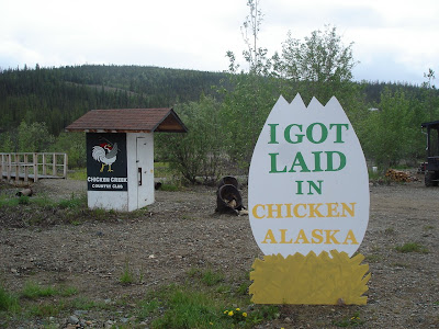
 Chicken, Alaska - population 21. This is beautiful downtown Chicken, a combination of store, restaurant, bar and gas station. Legend has it that miners looking for gold in the area 100 years ago hunted ptarmigan for food. They wanted to name the town "Ptarmigan", but none of them could spell it so they called it "Chicken" instead. It's a great place to stop for a break after driving the Top of the World.
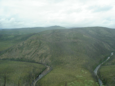 Despite the road, the views were great. Here you can see the South Fork Valley and its oxbow lakes. Along this road we saw evidence of several forest fires that have occurred in the past. This section of the road was closed for several days in the summer of 2004 because of fire.
 This is a view of the U.S. section of the Top of the World Highway. The Milepost magazine warned us that it is a narrow, winding road with no guardrails, steep grades, great views, soft shoulders and washboard and it did not tell a single lie. It continued on for another 13 miles past the border where it joined the Taylor Highway heading southbound.
 June 18 - Welcome to Alaska! We made it! The U.S./Canada border is 66 miles from Dawson City and just 2 miles from the highest point on the Top of the World highway - 4515 feet.
 It was another gloomy day with intermittent rain so as we neared Denali National Park we realized we probably wouldn't get a great view Mount McKinley (now known as Mount Denali). We did manage to get this shot from Denali Viewpoint North, but hoped we'd have better luck at viewpoints further south. We couldn't believe the touristy area that had grown up just outside the park; it was like a miniature Banff offering accommodations, bus tours, rafting, helicopter and airplane rides and restaurants. You can only drive 15 miles into the national park. If you want to go further you must pay to take a tour or shuttle bus and, of course, there is no guarantee you will see Denali. Apparently the entire mountain can only be seen clearly 20% of the time so the odds are not good. We decided to keep going and camped further south at a turnout in Denali State Park right near what was supposed to be a good viewpoint for the mountain. Unfortunately it poured rain from 4:00 that afternoon and it was still pouring rain the next morning so our hopes of getting a really good picture were dashed. Maybe next time!
 The Alaska Railroad crosses the Parks highway several times. Some of the crossings have solar collectors to help power the signals.
 June 23 - Travelling down the Parks Highway from Fairbanks towards Anchorage, we passed through the town of Nenana, a small town best known for the Nenana Ice Classic. This is an annual event that began in 1917 that awards cash prizes to the lucky winners who guess the exact minute of the ice breakup on the Tanana River. Tickets can be purchased from February 1 to April 5th. A tripod (like the one above) is placed into the ice in February; when the surging ice on the Tanana River dislodges the tripod, a line attached to the tripod trips a clock located in a tower on top the Ice Classic office, thus recording the official breakup time. Then the party begins!
 Also located at Chena Hot Springs is the Aurora Ice Museum and Stolis Ice Bar. Unfortunately we missed the tours that day, but apparently you can have a martini in a glass made from pure Alaska ice, have a wedding in the ice chapel or see the reindeer hide-covered beds. Since it's our mission to escape from the cold, I don't think Ted would have set foot in there anyway. One thing this resort had multitudes of was mosquitoes. We were actually swarmed by them when we got out of the truck. I had never seen anything quite like it. No bites, though!
 Chena Hot Springs - a wonderful outdoor natural hot springs rock lake. The outdoor pool was for adults only; indoor pools were available for children. It was so hot and relaxing.
 June 22 - After a day of laundry and cleaning house/truck, we decided to relax by going on a drive to Chena Hot Springs, 60 miles west of Fairbanks. It's not often you see this sign, but the area around Two Rivers is home to a number of dog mushers, including 5-time Iditarod champion Rick Swenson. There is a large system of mushing trails here and the Yukon Quest dog sled trail runs through Two Rivers. This was also a great road to see moose. Unfortunately one of them was hit by a SUV shortly before we arrived on the scene. No one was hurt, but the moose was killed.
 And then there was this guy who decided to take advantage of the crowds to convert some "skaters" to his warped point of view. A bit of a shouting match ensued as you can imagine! We were actually quite relieved to go home to some peace and quiet.
  Some residents found other ways to enjoy the day; boating down the Chena River which runs right through Fairbanks looked like fun. Later in the evening many people attended the annual Midnight Sun Game - a baseball game that starts at 10:30 p.m. and usually ends around 2:00 a.m. - all under natural light!
 Everyone was at the Midnight Sun Festival - the largest one-day event in Fairbanks. Live music on 3 stages from over 40 bands, gold panning, craft vendors, strolling entertainment, children's fairground rides - you name it, it was available here. They blocked off several streets and it was jam-packed with people. It was a crazy place to be especially when we'd only had 4 hours of sleep the night before.
 We were surprised at how few people were in the Park, but we realized why when we headed to downtown Fairbanks.
 On Gold Rush Street and Sourdough Way were many unique shops housed in original log cabins from around the state. The Gold Rush Town also includes the Palace Theatre and Saloon and a Dance Hall. I'd hate to meet up with this grizzly in real life!
 Our first stop was the Crooked Creek & Whiskey Island Railroad which took us twice around the park. Ted had a big chat with the employees about railroad history in this area.
 Pioneer Park in Fairbanks. This park was built to commemorate the 100th anniversary of the purchase of Alaska from Russia and is just filled with pieces of Alaskan history. It is home to Engine No. 1 (Fairbanks' first steam locomotive), the President Warren G. Harding Railroad Car, the Sternwheeler Nenana, Hard Rock Mine, a salmon bake restaurant, a Pioneer Air Museum and a Native Museum as well as picnic shelters, mini-golf and playgrounds.
 Of course, it makes sense when you realize it's across the street from the Malamute Saloon (which is currently closed for renovations). This is the saloon where Dangerous Dan McGrew was shot according to Robert Service's poem, "The Shooting of Dan McGrew". The town of Ester is now known for its artists - painters, jewellers, photographers, hat-makers, woodworkers, to name just a few.
 From North Pole to Ester and one of the more unusual signs we've seen in our travels.
 Santa's reindeer were spending the summer here, too. The picture's a little weird because it was taken through a wire fence. I'm not sure which reindeer this was, but I know it wasn't Rudolph. Did you know that reindeer are really tame caribou? Me neither until now!
 The best thing about Santa Claus House was Santa himself. While Mrs. Claus was on a break, Santa and I had a good chat. He told me (confidentially, of course) that he has such a great staff at the North Pole during the Christmas season that he only has to actually be there on the big night to deliver the presents. He and Mrs. Claus actually spend their winters at a RV park in Yuma, AZ (which shall remain nameless since he doesn't want people bothering him with their wish lists while he's on vacation). What a day - Arctic Circle, midnight sun and Santa Claus! Life is good.
 Santa Claus House cheered me right up. It was filled with Christmas trees, lights, ornaments, gifts - everything you could ever want to decorate your home for Christmas.
 We got home about 5:30 a.m. and were up at 9:30, thanks to Ted. He kept his watch on Alberta time and thought it was 11:30 which meant he thought we had slept for 6 hours. Unfortunately he didn't realize that we didn't go to bed until 7:30 a.m. Alberta time. I was a little "crabby" to say the least, but I got over it once we went to North Pole where the theme is "where the spirit of Christmas lives year round". Actually our campground was only about 6 miles west of North Pole so I can honestly say we stayed at North Pole.
 Here you can see the sun rising although it never really set. This picture was taken at 3:30 a.m.about 90 miles north of Fairbanks. Although the sun never sets at the Arctic Circle on summer solstice, 20-21 hours of sunlight are the norm in June and July in Fairbanks and Dawson City which made for some difficulty sleeping. However, I found we were so busy we could sleep no matter how light it was. The real problem was the birds that never stopped singing or chirping all night long!
 We reached the Yukon River Bridge at 2:45 a.m. This was probably the darkest it got. Here the pipeline and highway crosses the Yukon River.
  We left Gobblers Knob shortly after 1:00 and headed back towards Fairbanks. This was taken at 1:30 a.m.
 This was taken from Gobblers Knob at 1:00 a.m.
  June 21- We read that the best place to see the midnight sun on solstice was Gobblers Knob (M132 on the Dalton Highway) and they weren't kidding. Standing here you can watch the sun circle around overhead and never set! We had a great view of the Brooks Range to the north at midnight! You can see why they call it the "land of the midnight sun", but I'd sure hate to be here in December when the sun never rises!
 Ted achieved his goal - the Arctic Circle (Mile 115 on the Dalton Highway). This was taken at 11:30 p.m. on June 20th. Hard to believe, isn't it? It looks as if it should be mid-afternoon.
 The landscape changed as we headed north. Here we are crossing an area of alpine tundra where lichens, white mountain avens and dwarf shrubs are the most common vegetation.
 This strange-looking pile of rock is known as a tor - an isolated pinnacle of granite jutting out of the tundra. They are caused by erosion and can be seen all along this stretch of highway.
  Arctic Circle Trading Post (in Joy, AK) was built by the Carlsons who settled here with their 23 children (18 of whom were adopted). The sign still reads Wildwood General Store but it's been the Arctic Circle Trading post since 1997. A sign at the door reads "Not a single mosquito in Joy . . . they are all married with large families." We received a certificate saying that we'd made it to the Arctic Circle (even though we hadn't yet) and it was signed by a Carlson.
 Here you can see the pipeline zigzagging up the hill before it finally goes into the hill. This zigzag design allows the pipeline to flex and accommodate temperature changes. In some places the zigzag is much more extreme that what you see here. The pipeline, owned by the Aleyska Pipeline Service Co., is normally 48 inches in diameter (sometimes smaller), crosses an active fault line, three mountain ranges and hundreds of rivers and creek before reaching Valdez.
 June 20 - It was Ted's goal on this trip to be as north as we could go on the longest day of the year so we decided the Arctic Circle would be a good destination. We set out at 7:00 p.m. and headed north from Fairbanks. We travelled a small section of the Steese Highway to Fox and then 73 miles north on the Elliott Highway before we finally joined the Dalton Highway which goes all the way to Deadhorse (Prudhoe Bay) on the Arctic Ocean, a distance of 414 miles. Oil was discovered at Prudhoe Bay in 1969 and after Native land claims were settled, permits granted, environmental safeguards made, the road was built in just 5 months and the 800 mile long pipeline in 3 years (1974-77). At first the highway was called the Haul Road because almost everything supporting oil development was "hauled" on semis to is final destination. We only travelled 132 miles on the Dalton, but what an awesome drive it was! Here you can see the road winding off into the distance.
 At Delta Junction we started heading north on the Richardson Highway towards Fairbanks. The Richardson Highway extends 366 miles from Valdez on Prince William Sound to Fairbanks. It runs parallel to the trans-Alaska Pipeline the entire way. Known by gold miners in 1898 as the Valdez to Eagle Trail, it became Alaska's first road. This is the Tanana River Pipeline Crossing where the pipeline is suspended across the river.
 Mile 1422. Here I am proudly holding our certificate that verifies that we have reached the end of the Alaska Highway.
 . . . unlike this one, they aren't real! I found this crawling on the screen of our kitchen window. I don't know what it would take to kill this thing - not a fly swatter, that's for sure!
  June 19 - We continued on down the Taylor Highway to Tetlin Junction where we rejoined the Alaska Highway at M1301. We continued on through Tok where the highway followed the Tanana River to Delta Junction. They sure have giant insects here, but . . .
 No comment!
 Chicken, Alaska - population 21. This is beautiful downtown Chicken, a combination of store, restaurant, bar and gas station. Legend has it that miners looking for gold in the area 100 years ago hunted ptarmigan for food. They wanted to name the town "Ptarmigan", but none of them could spell it so they called it "Chicken" instead. It's a great place to stop for a break after driving the Top of the World.
 Despite the road, the views were great. Here you can see the South Fork Valley and its oxbow lakes. Along this road we saw evidence of several forest fires that have occurred in the past. This section of the road was closed for several days in the summer of 2004 because of fire.
 This is a view of the U.S. section of the Top of the World Highway. The Milepost magazine warned us that it is a narrow, winding road with no guardrails, steep grades, great views, soft shoulders and washboard and it did not tell a single lie. It continued on for another 13 miles past the border where it joined the Taylor Highway heading southbound.
 June 18 - Welcome to Alaska! We made it! The U.S./Canada border is 66 miles from Dawson City and just 2 miles from the highest point on the Top of the World highway - 4515 feet.
1 comment:
[url=http://sunkomutors.net/][img]http://sunkomutors.net/img-add/euro2.jpg[/img][/url]
[b]microsoft software license, [url=http://sunkomutors.net/]discounted microsoft office software[/url]
[url=http://sunkomutors.net/][/url] disadvantages of quarkxpress photoshop elements 7 for mac
linux software store [url=http://sunkomutors.net/]crack for filemaker pro 9[/url] shop 2.0 by software
[url=http://sunkomutors.net/]microsoft office onenote 2003 serial[/url] list of software resellers in
[url=http://sunkomutors.net/]free kaspersky internet security 2009 activation code[/url] macromedia fireworks 8 software
make xp switch between windows like vista [url=http://sunkomutors.net/]order free software cd[/b]
Post a Comment