Hi again! Same as usual. Scroll to the bottom for the oldest entries and then up for the latest.  The Kenai River does not have easily accessible, gently sloping riverbanks so the fishwalks allow people to fish without jeopardizing their safety or destroying the river bank environment.
 The Kenai River does not have easily accessible, gently sloping riverbanks so the fishwalks allow people to fish without jeopardizing their safety or destroying the river bank environment.
  Behind the Visitor Centre is one of several public fishwalks in the area constructed to make the popular Kenai River more accessible to the public.
 The actual mounted fish is on display at the Soldotna Visitor Center. It weighed in at 97.25 lbs. and was caught in 1985.
 June 30 - Back on the Sterling Highway heading to Seward. On our way we passed through Anchor Point, home to the most westernmost point in the American highway system and several Russian communities including Ninilchik and Nikiski. Many of these communities had beautiful Russian Orthodox churches. This wood carving (carved by Scott Hanson) of Les Anderson, record-holder for the largest sport-caught king salmon, is on display at Soldotna.
 A great view of what I believe are one or two of the mountains in the "Ring of Fire", a group of 4 mountains - Douglas, Augustine, Iliamna and Redoubt - that are all active volcanoes. Douglas has had no recent eruptions, but has had some fresh lava flow. Mount Augustine is an island that stands off the west shore 70 miles from Homer. It experienced 13 eruptions in 20 days in January, 2006. Iliamna has had no recent activity other than small earthquakes and Redoubt last erupted in 1990. Extreme skiers love Mount Redoubt.
 We were a little surprised to see a black bear walking up the road ahead of us.
 June 29 - What a difference a day makes! Here's the same view of the Spit and the mountains in beautiful sunshine.
 From the Skyline Drive we had the best view of Homer Spit. Unfortunately it was cloudy and overcast and starting to rain.
 We took a drive down the East End Road where we had awesome views of the Kachemak Bay glaciers and mountains. From Homer, the Grewingk, Portlock and Dixon glaciers are the most visible.
 While we were there, the annual Land's End Regatta was underway.
 Land's End Resort at the tip of Homer Spit. Condominiums look very out of place here; they just don't fit into the rugged landscape of Alaska (except maybe downtown Anchorage).
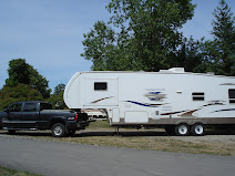
 The famous Fishing Hole, actually the Nick Dudiak Fishing Lagoon. It is stocked with king and silver salmon and as you can see, it is crowded with fishermen. Halibut is the most sought-after fish in this area, but salmon is a close second. The 2007 Halibut Derby winner caught a 358.4 lb. halibut using 1.5 lbs of octopus as bait. There are 13 oyster farms in the area and clamming is a popular pastime. Note all the RVs in the back parked next to the Lagoon. RVs and tents line the beaches on the Spit where you can camp for a nominal fee.
 The Seafarer's Memorial is dedicated to those who have lost their lives at sea. Their names are engraved on the floor tiles of the memorial.
 The famous Salty Dawg Saloon is an example of several buildings that were joined together to create this landmark. The lighthouse tower was once a water tower. The main part of the building was the headquarters for the Cook Inlet Coal Fields Co. and the post office and a schoolhouse make up the rest of the building.
 Besides junk, the Spit is also home to restaurants, gift shops, live theatre, campgrounds, canneries, motels, B & Bs, pubs, charter boat businesses, a major dock facility and small boat harbour. We had lunch at the Fresh Catch Cafe on the right. Ted had a seafood pasta and I had baked salmon. Pretty tasty!!
  According to the Milepost magazine, Alaskans do not like to throw anything away because they believe it will become valuable again someday. Sounds like someone I know!! This collection of various "treasures" has accumulated along the side of the road on the Spit. Quite an interesting array of junk!
 Homer Spit is a 5 mile long piece of land jutting into Kachemak Bay that is believed to be the remains of an ancient glacial moraine. It was inhabited over 1000 years ago by Dena'ina Indians and in the 1700s by the Russians. In the late 1800s coal was mined here and a railroad carried the coal out to the end of the spit to be hauled away on ships. From 1896 to 1902, the city of Homer was located on the tip of the Spit but it was abandoned and the new Homer was built on the base of the spit in the 1910s. Residents here place uprooted trees into the ground upside down so eagles will have a place to build their nests.
 June 28 - Homer, Alaska - Halibut Fishing Capital of the World - and home to some friends we met in Florida, NY and again in Kinzers, Pennsylvania. Ked and Diane have a fishing charter business in Homer, but unfortunately Ked had engine problems that took his boat out of commission for a week. Luckily for us, this gave us the opportunity to have coffee and a visit with them. Repairs were to be completed that afternoon and hopefully he was back in the water again.
 After driving the Seward Highway for 90 miles, we turned off at Tern Lake and headed down the Sterling Highway. This road took us through the Kenai Peninsula which is filled with rivers and lakes teeming with fish. The most popular fishing spots on this route were the Kenai and Russian Rivers and Skilak and Kenai Lakes which were lined with fishermen fishing for salmon, rainbow, Dolly Varden, arctic grayling and lake trout. Not being fisher-people, we were on the lookout for other attractions and we found one at the Town of Living Trees near Soldotna. Scott Hanson is a local carver who uses a chainsaw to carve various Alaskan animals including bears, moose, caribou and salmon. He has created an carved wooden carousel featuring Alaskan wild animals. This is a giant 10-foot high rocking chair.
 It certainly was on a very steep hillside. Being "unbalanced", I'd have fallen off, I'm sure!
 We may not have seen belugas or tidal bores, but we did see a Dall sheep on this hillside.
 June 27 - We are driving the Seward Highway towards Homer. This section of the road parallels Turnagain Arm which has so many interesting stops on it. Turnagain Arm got its name because Captain Cook got lost here and had to turn his ship - again - to get back out to sea. One stop on the highway was Potter Marsh where over 130 species of birds can be found. Another stop is Beluga Point where you can see bore tides and beluga whales (the only all-white ones). Turnagain Arm has one of the world's highest tides. A bore tide is an abrupt rise of tidal water just after a low tide formed by a flood tide surging into a narrow inlet such as Turnagain Arm. This wall of water can reach a height of 6 feet and is very dangerous to small boats. The best time to see it is 2 1/4 hours after low tide and it extends 32-37 miles south of Anchorage. Unfortunately we always seemed to be there at high tide so we never did see it. No belugas either!
 This is what the top part of the trail was like. When I got back down to where Ted was waiting, he asked me if I knew how to ride a bike. I said, "of course, why would you ask that?" and he replied that I looked "unbalanced" as I climbed up and down. I wasn't sure if he meant mentally or physically unbalanced so I thought it best not to pursue it. I'm pretty sure he meant physically, but you never know! How rude!
 Ted on top of the world (or at least Flattop Mountain). What a view from the top of Cook Inlet and the Alaska Range.
 This is a view of the trail (and me) from the top. The last part of the trail is steep and rocky and you need all four limbs to clamber to the top so Ted & I took turns as we knew Bailey and Rusty couldn't make it. I think they did very well going as far as they did. We were proud of our 4-legged Sherpas.
 From the rest area about 2/3 of the way up, we finally got our view of Mount Denali. We are quite a distance from the mountain so this gives you an idea of just how spectacular (and massive) it really is. As I was climbing up, I was starting to lag a little bit, but a local lady told me that there was a really good view of Denali that day from the viewpoint so that gave me the incentive to go on and it was worth it.
 June 26 - Behind Ted you can see the top of the aptly-named Flattop Mountain in Chugach State Park. We decided to hike to the top - a 3.5 mile round trip climb with an elevation gain of 1252 feet.
  We spent some time watching float planes landing and taking off on Lake Hood. Lake Hood is the world's largest and busiest seaplane base with approximately 800 takeoffs and landings on a peak summer day. From here you can drive to the airport and we found ourselves driving on actual runways. It was a little bizarre to say the least; of course, planes have the right of way! You not only have to look left and right, but also up.
 While driving the girls to the airport, we took a small detour to the town of Eklutna where we stopped at the cemetery. It is very unusual in that it contains a blend of Russian and Indian traditions. Originally a Dena'ina Indian village in 1650, it was also inhabited by Russians in the 1700s and the cemetery is filled with spirit houses and grave houses. We would have liked to look at it more closely, but there was an admission fee of $5.00 per person. We refused to pay to visit a cemetery. A donation box would seem more politically correct to me.
 June 25 - We drove about 25 miles north of Anchorage on the Glenn Highway to hike up to Thunderbird Falls and then stopped to have a look at Eklutna Lake which reminded us of Lake Louise. Eklutna Lake is the largest lake in Chugach State Park and a water source for Anchorage. On our way back we stopped to pick up two hitchhikers, Shannon and Katie, from New York. They had flown all the way to Anchorage to celebrate the summer solstice by taking part in the Mayor's Marathon on June 21. After it was over they decided to camp at Lake Eklutna for a couple of days but needed a ride to the airport to catch their flight back to NYC. They were really interesting girls - one was an interior designer and the other a medical researcher - and it was great to get opinions (political and otherwise) from a demographic other than senior citizens in campgrounds.
  On the way to Earthquake Park, we saw a moose beside the road. Apparently they show up in people's yards quite frequently.
 Earthquake Park. This statue and exhibit commemorate the 1964 Good Friday Earthquake, a 9.2 earthquake that caused damage to communities all along the Alaskan Gulf Coast. Anchorage was only 78 miles east of the epicentre of the most powerful earthquake to hit North America. Of the 125 people killed in Alaska, 9 died in Anchorage. Six other people died in Oregon and California. Most of the damage in Anchorage was caused by landslides, not the tsunamis that destroyed several other coastal towns. This park and Point Woronzof, 1 mile down the road, offer great views of Knik Arm, Cook Inlet and the mountains.
 If you think it's too cold in Alaska to grow beautiful flower beds and vegetable gardens, think again! You often see cabbage plants among the flower beds. They even have contests to see who can grow the largest cabbages.
 Earth is located at 5th and K Streets and you can continue on the Planet Walk by following the Tony Knowles Coastal Trail. The Coastal Trail extends 11 miles along the coastline of Cook Inlet and is a favorite of hikers, bikers and joggers.
 Starting at 5th Avenue and G Street, you can walk from the "Sun" out across the solar system on the Planet Walk.
 Anchorage has a beautiful, vibrant downtown. There were food vendors on street corners, musical groups playing in the parks and lots of things to see and do. This year marks the 6th anniversary of "Wild Salmon on Parade" featuring 26 weird and wonderful wild salmon sculptures and 3 halibut sculptures created by local artists and displayed throughout the downtown all summer long. At the end of the summer, a "Fish Fry and Buy" dinner auction is held where the Wild Salmon sculptures are sold to the highest bidders with the money raised going to local charities.
 A Russian expedition under Vitus Bering was the first to discover Alaska in 1728 although several native tribes already lived here. The Russians established a permanent settlement in Alaska in 1772 and it was also explored by Captain Cook's British Royal Navy in 1778. In 1867 William Seward, U.S. Secretary of State, negotiated the purchase of Alaska from Russia for $7.2 million - a real deal, I'd say. Although Alaska won't officially celebrate its 50th anniversary until January 3, 2009, celebrations were to begin on June 30th which marks the 50th anniversary of the day the U.S. Senate voted to make Alaska the 49th state.
  June 24 - Anchorage - Alaska's largest city with a population of over 282,000. The people of Anchorage make up 42% of Alaska's population. It is hemmed in by mountains, ocean, military bases and a state park. Cook Inlet's Knik Arm borders the northwestern side of Anchorage and Turnagain Arm lies on the southwestern end of the peninsula. The Chugach Mountains form a beautiful backdrop on the eastern side. This photo of downtown Anchorage was taken from Earthquake Park on Knik Arm.
No comments:
Post a Comment