We are slowing catching up! Only a few more months to go and we'll be up to date. Same drill as before - newest posts at the top and oldest at the bottom so scroll down to the bottom and work your way up. Captions are below the pictures. Enjoy!
 We ended the evening sitting around the campfire swapping stories.
 Our hosts - Don and Lynn - enjoying the meal.
 Junior and Chris were in the St. Patrick's Day spirit - matching T-shirts and all!
 March 17 - St. Patrick's Day at our neighbour's house. Don and Lynn and their friends from Washington cooked up a huge feast of corned beef and cabbage. It was simply delicious. Here Yvonne was making last minute preparations.
 Mel and Hunter enjoyed the slide and we enjoyed watching them. It was their last day with us and we wanted to make the most of it.
 We found the most amazing children's park at West Wetlands Park in Yuma. Hunter was a bit too young to enjoy it but give it a year and he'll be all over it.
 Kids don't need fancy toys - just give them an empty tub of Becel and a large container of coffee and you've got it made!
 March 7 - Hunter entertained all our neighbours when he walked up and down the street in his walker. People were coming out of their houses onto the street to watch him. He just loved it and practically wore out a pair of shoes.
 We enjoyed lunch beside the Old Well. This is one location I don't think I could find my way back to. We finally ended up at Walter's Camp, a boating facility between Blythe, CA and Yuma and took Ogilby Road home.
 March 6 - Desert Run!!! This time a group of us (12 in all) trekked out to Shale Mountain via Signature Hill on the California side of the Colorado River. This hill was covered in all shapes and sizes of loose shale.
 After lunch at Smoketree Point, we hiked the B wash again and discovered this green grassy area which looked just like a hole on a golf course to us. It's not often you see a lush green area like this in the desert.
 Hunter, Melanie and I having a rest along the trail.
 Hunter, Melanie and Ted at the highest point of the trail.
 March 4 - Mel and Hunter hiked the Painted Desert trail with us. Drumheller isn't the only place to have hoodoos.
 Our deck was a perfect place for Hunter to roam back and forth on his walker.
 February 28 - Melanie and Hunter arrived for a visit and we were thrilled to see them. Hunter isn't quite sure what to make of his first dill pickle.
 The view of Telegraph Hill and the Dome Valley in the background.
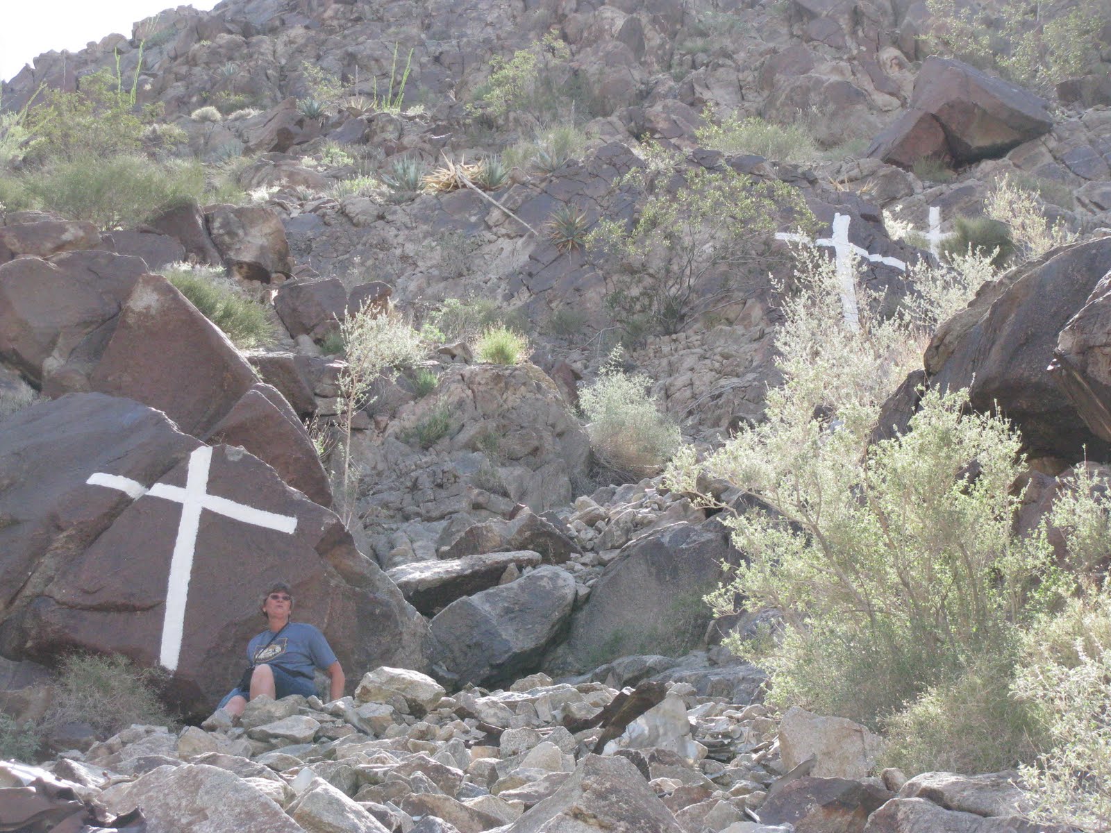 The last time we hiked up here with Clayton and Melanie, I made it to the first cross and Ted made it to second. This time I made it to the second and Ted made it to the fourth. Trust me - going down is much worse than going up!
 After reaching the first cross, the trail becomes much more difficult. At times you are just clambering over rocks with no real defined trail to follow.
 February 26 - B-17 Crash Site hike on Fortuna Peak. This time Don and Lynn, our neighbours, hiked with us. They did not quite make it to the first cross but came close. You can see Don making his way up the steep trail.
 The reason for the KEEP OUT sign!

Warning - Keep Out!! Several open mine shafts as well as the foundations of buildings at the Old Senator Mine were the destination of this hike.
 February 23 - Ted and I went for another hike - this time to the Old Senator Mine. We hiked up a ridge and it felt like we were on top of the world. Note the American flag on the hilltop behind Ted.
 After lunch we walked down another wash called the "B Wash". It, too, was an easy hike but had lots of fascinating terrain including this natural cave.
 Can't go on a hike without a little wildlife crossing your path.
 More spectacular scenery we saw from Smoketree Point.
 After our hike we stopped for lunch at Smoketree Point overlooking the Colorado River. We saw people in tour boats, motorboats and rafts all making their way down the river. The black rock you see is called tuff, a type of volcanic rock. The brown trails you see are made by burros making their way to the water and the round, brown area is called a dust bath where the burros roll in the dirt to increase insulation and ward off insects.
 More spectacular colours along the trail.
 You can see from the amazing colours why they call it the Painted Desert.
 February 17 - On our way to hike the Painted Desert Trail we stopped to admire beautiful Lake Martinez just north of Yuma.
 The picture that almost caused an international incident and almost landed me in jail! It had started raining again while we were on our way home. It finally stopped and a beautiful rainbow appeared while we were waiting for the bus to clear the border at Algodones. Passengers were not allowed to stay on the bus and had to walk through the Customs office. After I took this picture of the rainbow, a Customs officer came running towards our group, yelling at a man in front of me "Did you take a picture? What did you take a picture of?" The poor man looked stunned so I told the Customs officer that I took the picture. He asked me what I took the picture of and I told him "the rainbow". He calmed down a bit and told me in no uncertain terms that I was not to take a picture of any Customs personnel or the border crossing. I meekly said "Yes, sir" and he walked away. Wow - did I get told! We waited a long time for the bus to clear Customs and when it did it was minus the buffalo tail - only the pipe remained!
 You can't have a buffalo without a tail but don't ask me what Cathy was doing with it or to it. TMI - Too Much Information!
 Lunch was included so we enjoyed nachos and salsa as an appetizer and then Shrimp Louis for the main course. A margarita was also part of the deal so of course we couldn't pass that up. This was also the place where we could buy shrimp and halibut so we loaded up our coolers and headed home.
 However we were not alone; a huge pelican came to join us.
 Here we are on the beach at El Golfo on the Sea of Cortez. We practically had the beach to ourselves.
 As we drove into El Golfo, vendors lined the streets selling clams.
 The poverty in this area was appalling. People lived in shacks out in the desert with no visible means of income.
 Workers were out in the fields picking onions - apparently one of the most labour-intensive crops to harvest.
 Here we are in front of the Buffalo Bus. Now you know where it got its name! The five of us included me, Cathy, Audie, Doris and Linda.
 We started out in rain but it cleared up by the time we stopped for fish and/or shrimp tacos at a roadside stand. They were delicious.
 February 6 - Five of us girls decided to go to El Golfo, Mexico for a shrimp run. We left Yuma at 7:30 a.m. on the Buffalo Bus and headed out for a day of adventure. For some strange reason, our bus was instructed to cross the border at Mexicali which is about 60 miles west of Yuma while El Golfo is about 70 miles southeast of Yuma. Nothing like going miles out of your way! My impression of Mexicali was of one giant auto wrecking yard. There were miles and miles of old wrecked cars on both sides of the highway.
 This is what happens when you don't turn around when you should. Your vehicle becomes target practice because there is no way a tow truck is coming to your rescue.
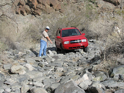 Further along, the trail became much more difficult. Dick and Lil were able to make it over the rocks with their Mitsubishi because it sits higher up, but our Tracker and Don and Cathy's Jimmy were too low to the ground to make it without possibly causing major damage. We did leave a little red paint on one of the rocks.
 February 3 - Another desert run!! This time we headed south onto the Barry Goldwater Range towards Woodcutter Pass. We stopped to check out one of the horizontal mines. Lil is already in the mine while Don is squeezing in between the rocks.
 Just west of Yuma on the California-Mexico border is a huge wall designed to keep the illegal aliens from coming into the U.S. The area along the border in both Arizona and California is constantly being patrolled by the border patrol.
 February 1 - "If you haven't been to Lutes, you haven't been to Yuma". This time we took our friends, Denis and Irene, who we first met at Rocky Harbour, Nfld. back in 2007. They were full-time RVers whose home base was Lethbridge and - biggest coincidence of all - they were good friends of Dale and Linda, our Moon River friends. While Dale was here, we all had supper together.
 January 27 - It was cabbage harvest time in Yuma. Agriculture is a 3 billion dollar industry in the Greater Yuma area. It is best known for its lettuce, cotton, hay, winter vegetables and cattle.

 February 23 - Ted and I went for another hike - this time to the Old Senator Mine. We hiked up a ridge and it felt like we were on top of the world. Note the American flag on the hilltop behind Ted.
 After lunch we walked down another wash called the "B Wash". It, too, was an easy hike but had lots of fascinating terrain including this natural cave.
 Can't go on a hike without a little wildlife crossing your path.
 More spectacular scenery we saw from Smoketree Point.
 After our hike we stopped for lunch at Smoketree Point overlooking the Colorado River. We saw people in tour boats, motorboats and rafts all making their way down the river. The black rock you see is called tuff, a type of volcanic rock. The brown trails you see are made by burros making their way to the water and the round, brown area is called a dust bath where the burros roll in the dirt to increase insulation and ward off insects.
 More spectacular colours along the trail.
 You can see from the amazing colours why they call it the Painted Desert.
 February 17 - On our way to hike the Painted Desert Trail we stopped to admire beautiful Lake Martinez just north of Yuma.
 The picture that almost caused an international incident and almost landed me in jail! It had started raining again while we were on our way home. It finally stopped and a beautiful rainbow appeared while we were waiting for the bus to clear the border at Algodones. Passengers were not allowed to stay on the bus and had to walk through the Customs office. After I took this picture of the rainbow, a Customs officer came running towards our group, yelling at a man in front of me "Did you take a picture? What did you take a picture of?" The poor man looked stunned so I told the Customs officer that I took the picture. He asked me what I took the picture of and I told him "the rainbow". He calmed down a bit and told me in no uncertain terms that I was not to take a picture of any Customs personnel or the border crossing. I meekly said "Yes, sir" and he walked away. Wow - did I get told! We waited a long time for the bus to clear Customs and when it did it was minus the buffalo tail - only the pipe remained!
 You can't have a buffalo without a tail but don't ask me what Cathy was doing with it or to it. TMI - Too Much Information!
 Lunch was included so we enjoyed nachos and salsa as an appetizer and then Shrimp Louis for the main course. A margarita was also part of the deal so of course we couldn't pass that up. This was also the place where we could buy shrimp and halibut so we loaded up our coolers and headed home.
 However we were not alone; a huge pelican came to join us.
 Here we are on the beach at El Golfo on the Sea of Cortez. We practically had the beach to ourselves.
 As we drove into El Golfo, vendors lined the streets selling clams.
 The poverty in this area was appalling. People lived in shacks out in the desert with no visible means of income.
 Workers were out in the fields picking onions - apparently one of the most labour-intensive crops to harvest.
 Here we are in front of the Buffalo Bus. Now you know where it got its name! The five of us included me, Cathy, Audie, Doris and Linda.
 We started out in rain but it cleared up by the time we stopped for fish and/or shrimp tacos at a roadside stand. They were delicious.
 February 6 - Five of us girls decided to go to El Golfo, Mexico for a shrimp run. We left Yuma at 7:30 a.m. on the Buffalo Bus and headed out for a day of adventure. For some strange reason, our bus was instructed to cross the border at Mexicali which is about 60 miles west of Yuma while El Golfo is about 70 miles southeast of Yuma. Nothing like going miles out of your way! My impression of Mexicali was of one giant auto wrecking yard. There were miles and miles of old wrecked cars on both sides of the highway.
 This is what happens when you don't turn around when you should. Your vehicle becomes target practice because there is no way a tow truck is coming to your rescue.
 Further along, the trail became much more difficult. Dick and Lil were able to make it over the rocks with their Mitsubishi because it sits higher up, but our Tracker and Don and Cathy's Jimmy were too low to the ground to make it without possibly causing major damage. We did leave a little red paint on one of the rocks.
 February 3 - Another desert run!! This time we headed south onto the Barry Goldwater Range towards Woodcutter Pass. We stopped to check out one of the horizontal mines. Lil is already in the mine while Don is squeezing in between the rocks.
  Just west of Yuma on the California-Mexico border is a huge wall designed to keep the illegal aliens from coming into the U.S. The area along the border in both Arizona and California is constantly being patrolled by the border patrol.
 February 1 - "If you haven't been to Lutes, you haven't been to Yuma". This time we took our friends, Denis and Irene, who we first met at Rocky Harbour, Nfld. back in 2007. They were full-time RVers whose home base was Lethbridge and - biggest coincidence of all - they were good friends of Dale and Linda, our Moon River friends. While Dale was here, we all had supper together.
 January 27 - It was cabbage harvest time in Yuma. Agriculture is a 3 billion dollar industry in the Greater Yuma area. It is best known for its lettuce, cotton, hay, winter vegetables and cattle.
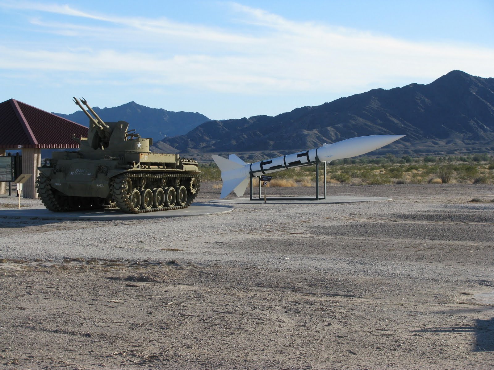
Just after you turn off Hwy 95 on to Lake Martinez Road there is a display of military artillery on the Yuma Proving Grounds.
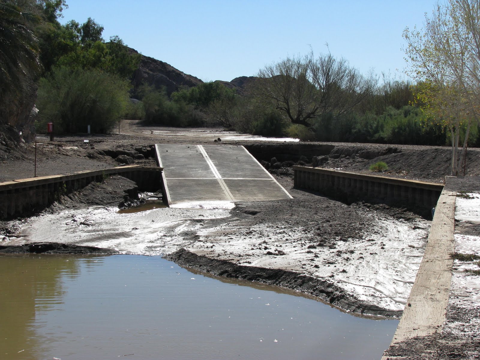
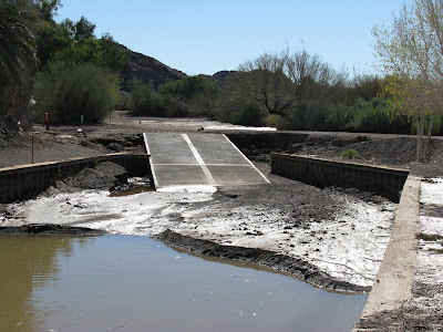 The boat launch at Picacho State Park was completely destroyed by flooding.
 Four days after the rain and water was still lying on the road to Picacho - something you rarely see. One positive outcome of the rain occurred a few weeks later when the desert started to bloom. It was awesome!
 January 25 - On the 24th our friend, Dale, who was our neighbour at Moon River, came for a short visit. He's an amazing photographer and wanted to get some photos of the desert so we took him out to Signature Hill and Picacho State Park.
 When we first came to Yuma, we wondered what these huge grassy areas that looked like empty dug-outs were for. We learned that they are actually drainage reservoirs and serve a very useful purpose during periods of heavy rain. This one, about 3 blocks from our place, was nearly full.
 When washes fill with water, vehicles are not supposed to drive through them as signs on each side of the wash indicate. As you can see this Chevy made it through (of course) but the County employee was not too impressed and stopped the driver to give him a warning.
 January 21 - We arrived back in Yuma on the 7th and kept busy visiting friends, wiring the deck and running errands. From the 19th to the 21st we had almost 3 inches of rain which is very unusual for Yuma. This shows how much water was running down the canal on 48th Street. We were ready to start building an Ark.
 On the way back we stopped at one of the large windows/vents carved into the side of the tunnel where we had an incredible view of the towering sandstone cliffs.
 On the other side of the tunnel we were greeted by three desert bighorn sheep.
 The Zion - Mt. Carmel Tunnel was built in the 1920s when cars were small and few in number. During the busy months visitors whose vehicles are oversize such as RVs, buses, trailers, etc. must be escorted through the tunnel by a pilot vehicle while rangers stop oncoming traffic. There is a $15 fee for this service. Fortunately we were there in the slow season so we were able to drive through the tunnel.
 The trail was extremely icy in spots and as we got closer to the bottom of the trail overlooking the Lower Emerald Pool, Ted actually slipped and started to fall beneath the guard rail. Luckily he grabbed onto the rail and pulled himself up. We slowly made our way back to the truck and decided to do our hiking when there is no ice present. I'm amazed it was Ted who slipped; I'm the klutz in our family!
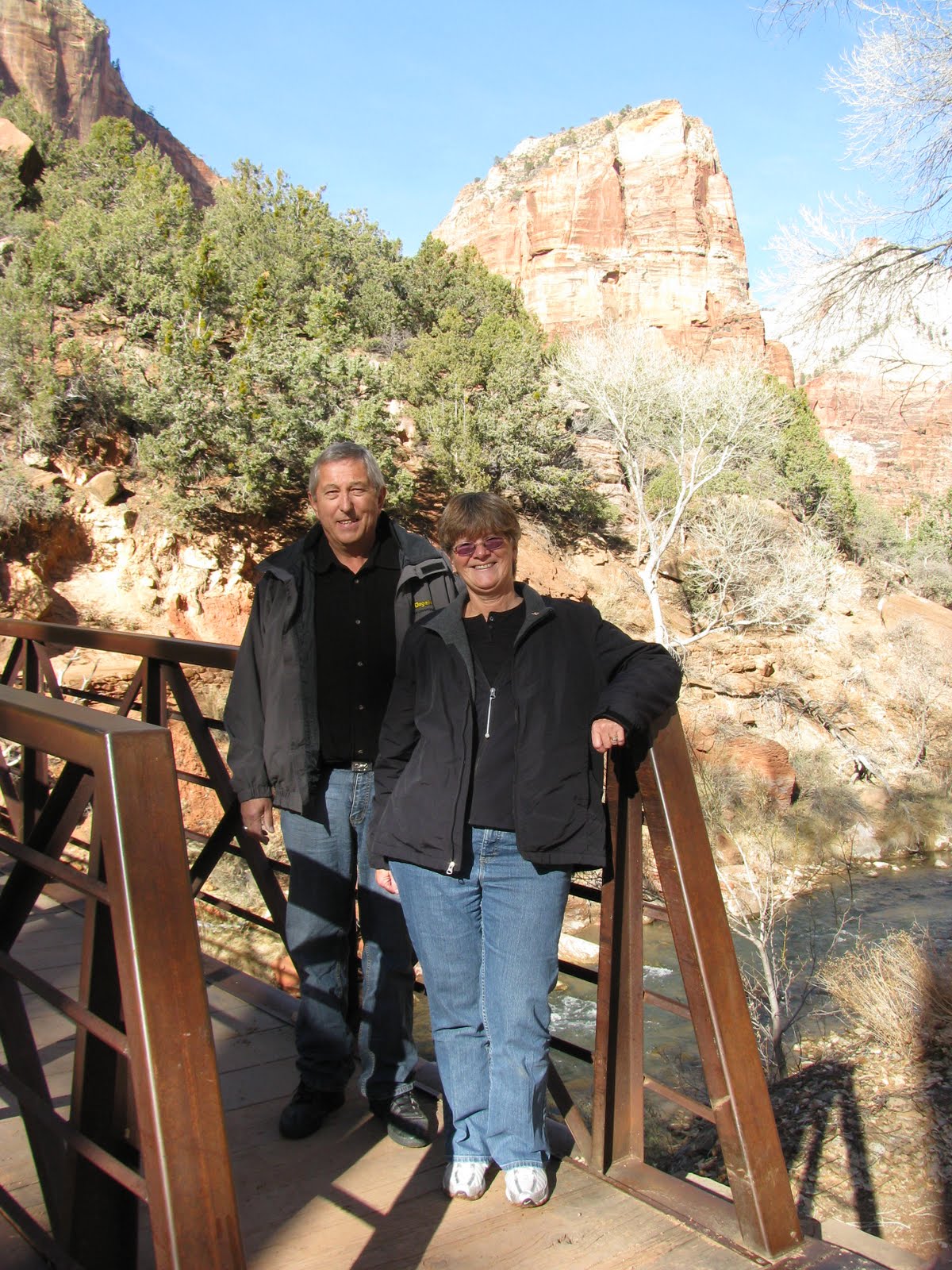
 Ted and I across the road from Zion Lodge ready to start our hike to the Lower Emerald Pool.
 Frozen remains of a waterfall
 Looking south from the Temple of Sinawava, the furthest point north on the Scenic Drive.
 Driving along the Zion Canyon Scenic Drive we saw this unusual tree. From spring through fall this road is open to shuttle buses only.
 Most of the national parks we have visited such as the Grand Canyon, Bryce and the Black Canyon of the Gunnison have trails and roads along the rim that allow you to look down into the canyon below. At Zion you drive through the bottom of the canyon and "look up, look way, way up" as the Friendly Giant used to say. Boy, does that date me!!!
 January 6, 2010 - We left Lethbridge on the 4th and decided to spend a few days around St. George, Utah exploring Zion National Park. We had visited Bryce Canyon 20 years ago with the kids and decided it was time to check out the beautiful pink, white and red rocks of Zion.
 The boat launch at Picacho State Park was completely destroyed by flooding.
 Four days after the rain and water was still lying on the road to Picacho - something you rarely see. One positive outcome of the rain occurred a few weeks later when the desert started to bloom. It was awesome!
 January 25 - On the 24th our friend, Dale, who was our neighbour at Moon River, came for a short visit. He's an amazing photographer and wanted to get some photos of the desert so we took him out to Signature Hill and Picacho State Park.
 When we first came to Yuma, we wondered what these huge grassy areas that looked like empty dug-outs were for. We learned that they are actually drainage reservoirs and serve a very useful purpose during periods of heavy rain. This one, about 3 blocks from our place, was nearly full.
 When washes fill with water, vehicles are not supposed to drive through them as signs on each side of the wash indicate. As you can see this Chevy made it through (of course) but the County employee was not too impressed and stopped the driver to give him a warning.
 January 21 - We arrived back in Yuma on the 7th and kept busy visiting friends, wiring the deck and running errands. From the 19th to the 21st we had almost 3 inches of rain which is very unusual for Yuma. This shows how much water was running down the canal on 48th Street. We were ready to start building an Ark.
 On the way back we stopped at one of the large windows/vents carved into the side of the tunnel where we had an incredible view of the towering sandstone cliffs.
 On the other side of the tunnel we were greeted by three desert bighorn sheep.
 The Zion - Mt. Carmel Tunnel was built in the 1920s when cars were small and few in number. During the busy months visitors whose vehicles are oversize such as RVs, buses, trailers, etc. must be escorted through the tunnel by a pilot vehicle while rangers stop oncoming traffic. There is a $15 fee for this service. Fortunately we were there in the slow season so we were able to drive through the tunnel.
 The trail was extremely icy in spots and as we got closer to the bottom of the trail overlooking the Lower Emerald Pool, Ted actually slipped and started to fall beneath the guard rail. Luckily he grabbed onto the rail and pulled himself up. We slowly made our way back to the truck and decided to do our hiking when there is no ice present. I'm amazed it was Ted who slipped; I'm the klutz in our family!
 Ted and I across the road from Zion Lodge ready to start our hike to the Lower Emerald Pool.
 Frozen remains of a waterfall
 Looking south from the Temple of Sinawava, the furthest point north on the Scenic Drive.
 Driving along the Zion Canyon Scenic Drive we saw this unusual tree. From spring through fall this road is open to shuttle buses only.
 Most of the national parks we have visited such as the Grand Canyon, Bryce and the Black Canyon of the Gunnison have trails and roads along the rim that allow you to look down into the canyon below. At Zion you drive through the bottom of the canyon and "look up, look way, way up" as the Friendly Giant used to say. Boy, does that date me!!!
 January 6, 2010 - We left Lethbridge on the 4th and decided to spend a few days around St. George, Utah exploring Zion National Park. We had visited Bryce Canyon 20 years ago with the kids and decided it was time to check out the beautiful pink, white and red rocks of Zion.