April 2 - Pahrump, NV - Our escape from the cold is almost over for this winter. Tomorrow we start heading to the not-so-warm north. We hope to be back in Lethbridge by Sunday. We will update the last few weeks of our journey when we return "home". Thanks for your patience - stay tuned!
Well, we're heading west now on the long trek back home. We took a little jog north into New Mexico to see Roswell and Carlsbad and then headed back into Texas on our route west. You know the drill - newest entries at the top, captions below the pictures. .JPG) This is a cluster of 4 Mogollon masks repesenting their ancestral spirits. More than 200 mask pictographs have been found at Hueco Tanks, the largest collection in North America.
This is a cluster of 4 Mogollon masks repesenting their ancestral spirits. More than 200 mask pictographs have been found at Hueco Tanks, the largest collection in North America.
.JPG) These are just a few of the pictographs that we saw beneath the rock. The colour was incredible considering they were painted hundreds of years ago.
These are just a few of the pictographs that we saw beneath the rock. The colour was incredible considering they were painted hundreds of years ago.
.JPG) At one point we had to crawl into a very narrow space under a large overhanging rock where we saw a group of beautiful pictographs preserved from the elements. It was well worth the claustrophobia.
At one point we had to crawl into a very narrow space under a large overhanging rock where we saw a group of beautiful pictographs preserved from the elements. It was well worth the claustrophobia.
 Other tribes who lived in the area are the Kiowa, Mescalero Apache and Tigua. This pictograph is part of a rock painting depicting white dancing figures. It was done by the Mescalero Apaches around 1800 AD.
 Over 2000 pictographs have been found in the Park - in crevices, under rocks, in caves. Some date back as far as 10,000 years ago. Most of the pictographs were done by the Jornada Mogollon tribe. Our guide showed us their art, pottery shards, mortars and ancient earthen dams. Most of the art pictured animals, birds and large-eyed figures but the most famous images are the masks.
 Hueco Tanks is famous for its rock art and ancient pictographs. This overhanging rock provided shelter at a stopping point on the Butterfield Overland Mail run and, as you can see, people carved their names over the pictographs as long ago as 1884. I guess vandalism isn't a modern phenomenon. I think the picture of the man in the cowboy hat must be a self-portrait!
 March 8 - On our last morning at Hueco Tanks, I took a guided rock art/pictograph tour. Our guide, Ed, was extremely knowledgeable about the Park. He grew up in the area and used to camp out here as a boy long before it was a park and visitation was restricted. He became a volunteer just so he could visit the Park whenever he wished.
 These are the trams which carried us up the mountain. We rose 946 feet in 4 minutes to a height of 5,632 feet.
 The view to the west - on the right is New Mexico and far off in the distance is Arizona.
.JPG) Here you can see downtown El Paso and just beyond it, on the other side of the Rio Grande, is Juarez - the 4th largest city in Mexico.
Here you can see downtown El Paso and just beyond it, on the other side of the Rio Grande, is Juarez - the 4th largest city in Mexico.
.JPG) March 7 - We took the Wyler Aerial Tramway to the top of Ranger Peak in El Paso's Franklin Mountains. From the top you can see 2 countries (U.S. & Mexico) and 3 states (Texas, New Mexico and Arizona (in the distance). This is a view to the east - the airport, Fort Bliss and Biggs U.S. Army Airfield.
March 7 - We took the Wyler Aerial Tramway to the top of Ranger Peak in El Paso's Franklin Mountains. From the top you can see 2 countries (U.S. & Mexico) and 3 states (Texas, New Mexico and Arizona (in the distance). This is a view to the east - the airport, Fort Bliss and Biggs U.S. Army Airfield.
 Another view from the top.
 I waited below to call 911 in case Ted fell (unfortunately there was no cell service here - oops!!). I had no desire to climb (or scramble, as Ted called it) straight up large boulders using only my fingernails.
 Ted, being Ted, had to climb to the highest point on the North Mountain. Far below you can see the Park Visitor Centre.
 This is one of the larger huecos we saw - most held no water because of the drought conditions. Hopefully the rainy season will soon begin.
 The Park is named Hueco Tanks after the huecos (hollows) found in the rock. Over 34 million years ago, magma pushed up into an older limestone formation and then cooled. Weathering eroded the overlying limestone and carved the now-exposed igneous rock into its present form. The huecos hold and trap precious water in the desert and the rocks provide shelter and shade so the area has been able to support people, plants and animals for thousands of years.
 This is one small pile of rocks on the North Mountain.
 Welcome to Hueco Tanks State Historic Park located in the Chihuahuan Desert about 20 miles east of El Paso. We stayed in the campground here for 4 nights and would have liked to stay longer except it was booked solid for spring break by rock climbers. The area looks as if God picked up a mountain and dropped it, shattering it into 3 large piles of huge rocks. The Park limits the number of visitors and only the North Mountain can be explored without a guide.
 Also in the Park is the peak known as El Capitan (8085 feet). There are lots of great trails in the Park that we'd like to hike someday.
 March 4 - On our way to El Paso, TX, we stopped at Guadalupe Mountains National Park for lunch. This is the highest peak in Texas (8749 feet).
 When we left Carlsbad Caverns, we took a drive through Lincoln National Forest. We had hoped to visit Sitting Bull Falls, but the gates were already closed. As you can see, the snow still hadn't melted.
 After eating lunch at a cafeteria 750 feet below the surface, we entered the Big Room. It is 8.2 acres in size (14 football fields) and absolutely filled with every type of cave formation possible. The highlights included the Bottomless Pit, Rock of Ages and Painted Grotto. Seen above are the Giant Dome and Twin Domes. When the tour was over we took an elevator to the top which sure beat walking the 750 feet back to the surface.
 The Natural Entrance and the Big Room Routes were both self-guiding tours, but we rented the audio-phones to get the most out of it. To enter any of the other caverns, you must be accompanied by a guide. In the Natural Entrance, we descended 750 feet via a series of steep switchbacks and saw the Bat Cave, Devil's Spring and Iceberg Rock, a 200,000-ton boulder that fell from the cave ceiling thousands of years ago. In this picture a stalactite is growing towards a stalagmite. They are only a few inches apart, but it will probably take thousands of years before they meet to form a column.
 This is the mouth of the Natural Entrance of the cavern as seen from the steps of the amphitheatre. Carlsbad Cavern was discovered by local cowboy, Jim White, in 1901. He explored it for the next 30 years and made amazing discoveries. This is definitely the best Cavern we have visited although Ted remarked that Luray is still the most colourful.
.JPG) We made the best of it, however, by visiting the Carlsbad Caverns where the temperature was much warmer down below than it was above ground. In the picture you can see the amphitheatre where people gather at dusk from April to November to watch thousands of Mexican free-tailed bats leave the cavern on their nightly search for food. The mass exodus can last from 20 minutes to 2 1/2 hours. Only a few bats had returned this early so we didn't see any.
We made the best of it, however, by visiting the Carlsbad Caverns where the temperature was much warmer down below than it was above ground. In the picture you can see the amphitheatre where people gather at dusk from April to November to watch thousands of Mexican free-tailed bats leave the cavern on their nightly search for food. The mass exodus can last from 20 minutes to 2 1/2 hours. Only a few bats had returned this early so we didn't see any.
 March 3 - THE UNTHINKABLE - SNOW!!!! Ted was devastated when we stuck our noses out the trailer door and saw snow-covered ground in New Mexico!! This wasn't supposed to happen!
 Up close and personal with a rattlesnake. Thank heaven there was glass between us. I don't know what it is about Ted, but he managed to upset it somehow and you actually hear its tail rattling through the glass.
 This is one of six Mexican gray wolves at the Zoo; these are an endangered species. Other animals at the Zoo include cougars, bobcats, bison, elk, javelinas, prairie dogs and mule deer.
 Meet Maggie, the bear, a member of the local art community. Maggie loves to cover her paws in paint and walk across sheets of paper strewn on the floor. Her paintings are then matted, framed, displayed and sold at the Visitor Centre. She was near death and traumatized when she came to the Zoo from Georgia and painting is part of her therapy.
 This area is part of the Chihuahuan Desert and on the self-guided tour we saw cacti, succulents, juniper trees, pinon, sand dunes and desert uplands. The cacti were just starting to bloom.
.JPG) March 2 - It was a beautiful day so we spent the day outside at the Living Desert Zoo & Gardens State Park in Carlsbad. It's a safe haven for animals who have been injured or orphaned. Above you can see a one-legged roadrunner. Roadrunners prefer not to fly and can run as fast as 15 mph (on two legs, of course!)
March 2 - It was a beautiful day so we spent the day outside at the Living Desert Zoo & Gardens State Park in Carlsbad. It's a safe haven for animals who have been injured or orphaned. Above you can see a one-legged roadrunner. Roadrunners prefer not to fly and can run as fast as 15 mph (on two legs, of course!)
 I took the opportunity to make a few new friends. Beam me up, Scotty!!
 This is one of the displays in the Museum. The exhibits could use some updating - the movie was over 20 years old. The Museum includes a day-to-day accounting of events including witness testimonies, photographs, maps and newspapers. There are also exhibits on crop circles, UFO encounters, Area 51, etc.
 March 1 - Being huge X-Files fans, we had to make the trip to Roswell, site of the infamous "Roswell Incident". On July 4, 1947 a UFO allegedly crashed in a field about 70 miles outside of town. Mac Brazel, the ranch hand who found the UFO, brought the debris to Roswell a couple of days later. A local newspaper reported the incident on July 8, 1947, but the next day a press release was issued stating it was just a weather balloon that had crashed and that was the start of the Roswell Incident cover-up. The Museum is currently housed in an old movie theatre and is trying to raise money to build a more UFO-like building. Note: the street lights have alien faces!
 February 29 - This is our campsite in Brantley Lake State Park, New Mexico just a few miles north of Carlsbad. We can't say enough about the state park campgrounds - power, water, large sites, picnic shelters - some even provide clothes lines and sewer - at a very reasonable price.
.JPG) This is a cluster of 4 Mogollon masks repesenting their ancestral spirits. More than 200 mask pictographs have been found at Hueco Tanks, the largest collection in North America.
This is a cluster of 4 Mogollon masks repesenting their ancestral spirits. More than 200 mask pictographs have been found at Hueco Tanks, the largest collection in North America.
.JPG) These are just a few of the pictographs that we saw beneath the rock. The colour was incredible considering they were painted hundreds of years ago.
These are just a few of the pictographs that we saw beneath the rock. The colour was incredible considering they were painted hundreds of years ago.
.JPG) At one point we had to crawl into a very narrow space under a large overhanging rock where we saw a group of beautiful pictographs preserved from the elements. It was well worth the claustrophobia.
At one point we had to crawl into a very narrow space under a large overhanging rock where we saw a group of beautiful pictographs preserved from the elements. It was well worth the claustrophobia.
 Other tribes who lived in the area are the Kiowa, Mescalero Apache and Tigua. This pictograph is part of a rock painting depicting white dancing figures. It was done by the Mescalero Apaches around 1800 AD.
 Over 2000 pictographs have been found in the Park - in crevices, under rocks, in caves. Some date back as far as 10,000 years ago. Most of the pictographs were done by the Jornada Mogollon tribe. Our guide showed us their art, pottery shards, mortars and ancient earthen dams. Most of the art pictured animals, birds and large-eyed figures but the most famous images are the masks.
 Hueco Tanks is famous for its rock art and ancient pictographs. This overhanging rock provided shelter at a stopping point on the Butterfield Overland Mail run and, as you can see, people carved their names over the pictographs as long ago as 1884. I guess vandalism isn't a modern phenomenon. I think the picture of the man in the cowboy hat must be a self-portrait!
 March 8 - On our last morning at Hueco Tanks, I took a guided rock art/pictograph tour. Our guide, Ed, was extremely knowledgeable about the Park. He grew up in the area and used to camp out here as a boy long before it was a park and visitation was restricted. He became a volunteer just so he could visit the Park whenever he wished.
 These are the trams which carried us up the mountain. We rose 946 feet in 4 minutes to a height of 5,632 feet.
 The view to the west - on the right is New Mexico and far off in the distance is Arizona.
.JPG) Here you can see downtown El Paso and just beyond it, on the other side of the Rio Grande, is Juarez - the 4th largest city in Mexico.
Here you can see downtown El Paso and just beyond it, on the other side of the Rio Grande, is Juarez - the 4th largest city in Mexico.
.JPG) March 7 - We took the Wyler Aerial Tramway to the top of Ranger Peak in El Paso's Franklin Mountains. From the top you can see 2 countries (U.S. & Mexico) and 3 states (Texas, New Mexico and Arizona (in the distance). This is a view to the east - the airport, Fort Bliss and Biggs U.S. Army Airfield.
March 7 - We took the Wyler Aerial Tramway to the top of Ranger Peak in El Paso's Franklin Mountains. From the top you can see 2 countries (U.S. & Mexico) and 3 states (Texas, New Mexico and Arizona (in the distance). This is a view to the east - the airport, Fort Bliss and Biggs U.S. Army Airfield.
 Another view from the top.
 I waited below to call 911 in case Ted fell (unfortunately there was no cell service here - oops!!). I had no desire to climb (or scramble, as Ted called it) straight up large boulders using only my fingernails.
 Ted, being Ted, had to climb to the highest point on the North Mountain. Far below you can see the Park Visitor Centre.
 This is one of the larger huecos we saw - most held no water because of the drought conditions. Hopefully the rainy season will soon begin.
 The Park is named Hueco Tanks after the huecos (hollows) found in the rock. Over 34 million years ago, magma pushed up into an older limestone formation and then cooled. Weathering eroded the overlying limestone and carved the now-exposed igneous rock into its present form. The huecos hold and trap precious water in the desert and the rocks provide shelter and shade so the area has been able to support people, plants and animals for thousands of years.
 This is one small pile of rocks on the North Mountain.
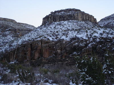
 Welcome to Hueco Tanks State Historic Park located in the Chihuahuan Desert about 20 miles east of El Paso. We stayed in the campground here for 4 nights and would have liked to stay longer except it was booked solid for spring break by rock climbers. The area looks as if God picked up a mountain and dropped it, shattering it into 3 large piles of huge rocks. The Park limits the number of visitors and only the North Mountain can be explored without a guide.
 Also in the Park is the peak known as El Capitan (8085 feet). There are lots of great trails in the Park that we'd like to hike someday.
 March 4 - On our way to El Paso, TX, we stopped at Guadalupe Mountains National Park for lunch. This is the highest peak in Texas (8749 feet).
 When we left Carlsbad Caverns, we took a drive through Lincoln National Forest. We had hoped to visit Sitting Bull Falls, but the gates were already closed. As you can see, the snow still hadn't melted.
 After eating lunch at a cafeteria 750 feet below the surface, we entered the Big Room. It is 8.2 acres in size (14 football fields) and absolutely filled with every type of cave formation possible. The highlights included the Bottomless Pit, Rock of Ages and Painted Grotto. Seen above are the Giant Dome and Twin Domes. When the tour was over we took an elevator to the top which sure beat walking the 750 feet back to the surface.
 The Natural Entrance and the Big Room Routes were both self-guiding tours, but we rented the audio-phones to get the most out of it. To enter any of the other caverns, you must be accompanied by a guide. In the Natural Entrance, we descended 750 feet via a series of steep switchbacks and saw the Bat Cave, Devil's Spring and Iceberg Rock, a 200,000-ton boulder that fell from the cave ceiling thousands of years ago. In this picture a stalactite is growing towards a stalagmite. They are only a few inches apart, but it will probably take thousands of years before they meet to form a column.
 This is the mouth of the Natural Entrance of the cavern as seen from the steps of the amphitheatre. Carlsbad Cavern was discovered by local cowboy, Jim White, in 1901. He explored it for the next 30 years and made amazing discoveries. This is definitely the best Cavern we have visited although Ted remarked that Luray is still the most colourful.
.JPG) We made the best of it, however, by visiting the Carlsbad Caverns where the temperature was much warmer down below than it was above ground. In the picture you can see the amphitheatre where people gather at dusk from April to November to watch thousands of Mexican free-tailed bats leave the cavern on their nightly search for food. The mass exodus can last from 20 minutes to 2 1/2 hours. Only a few bats had returned this early so we didn't see any.
We made the best of it, however, by visiting the Carlsbad Caverns where the temperature was much warmer down below than it was above ground. In the picture you can see the amphitheatre where people gather at dusk from April to November to watch thousands of Mexican free-tailed bats leave the cavern on their nightly search for food. The mass exodus can last from 20 minutes to 2 1/2 hours. Only a few bats had returned this early so we didn't see any.
 March 3 - THE UNTHINKABLE - SNOW!!!! Ted was devastated when we stuck our noses out the trailer door and saw snow-covered ground in New Mexico!! This wasn't supposed to happen!
 Up close and personal with a rattlesnake. Thank heaven there was glass between us. I don't know what it is about Ted, but he managed to upset it somehow and you actually hear its tail rattling through the glass.
 This is one of six Mexican gray wolves at the Zoo; these are an endangered species. Other animals at the Zoo include cougars, bobcats, bison, elk, javelinas, prairie dogs and mule deer.
 Meet Maggie, the bear, a member of the local art community. Maggie loves to cover her paws in paint and walk across sheets of paper strewn on the floor. Her paintings are then matted, framed, displayed and sold at the Visitor Centre. She was near death and traumatized when she came to the Zoo from Georgia and painting is part of her therapy.
 This area is part of the Chihuahuan Desert and on the self-guided tour we saw cacti, succulents, juniper trees, pinon, sand dunes and desert uplands. The cacti were just starting to bloom.
.JPG) March 2 - It was a beautiful day so we spent the day outside at the Living Desert Zoo & Gardens State Park in Carlsbad. It's a safe haven for animals who have been injured or orphaned. Above you can see a one-legged roadrunner. Roadrunners prefer not to fly and can run as fast as 15 mph (on two legs, of course!)
March 2 - It was a beautiful day so we spent the day outside at the Living Desert Zoo & Gardens State Park in Carlsbad. It's a safe haven for animals who have been injured or orphaned. Above you can see a one-legged roadrunner. Roadrunners prefer not to fly and can run as fast as 15 mph (on two legs, of course!)
 I took the opportunity to make a few new friends. Beam me up, Scotty!!
  This is one of the displays in the Museum. The exhibits could use some updating - the movie was over 20 years old. The Museum includes a day-to-day accounting of events including witness testimonies, photographs, maps and newspapers. There are also exhibits on crop circles, UFO encounters, Area 51, etc.
 March 1 - Being huge X-Files fans, we had to make the trip to Roswell, site of the infamous "Roswell Incident". On July 4, 1947 a UFO allegedly crashed in a field about 70 miles outside of town. Mac Brazel, the ranch hand who found the UFO, brought the debris to Roswell a couple of days later. A local newspaper reported the incident on July 8, 1947, but the next day a press release was issued stating it was just a weather balloon that had crashed and that was the start of the Roswell Incident cover-up. The Museum is currently housed in an old movie theatre and is trying to raise money to build a more UFO-like building. Note: the street lights have alien faces!
 February 29 - This is our campsite in Brantley Lake State Park, New Mexico just a few miles north of Carlsbad. We can't say enough about the state park campgrounds - power, water, large sites, picnic shelters - some even provide clothes lines and sewer - at a very reasonable price.


