We really loved San Antonio and the Hill Country. There's so much to see and do in Texas - we've only scratched the surface. We'll definitely be back again. Just a reminder - most recent pictures at the top, oldest at the bottom, captions are below the pictures.  February 29 - Oil and gas wells dotted the landscape north of Fort Stockton. Wind power and fossil fuels - western Texas is making use of both.
 February 28 - On our way to New Mexico, we saw hundreds of wind turbines, most of them on top of mesas. These were located just east of Fort Stockton and reminded us of Fort Macleod and Pincher Creek.
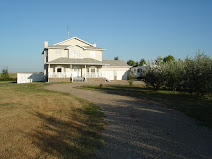
 After showing you beautiful historic buildings, we thought we should show you a contemporary one. This house was on the other side of the Guadalupe River from the road to our campground and everytime we went by we remarked on how unique (??) it was. We finally had to take a closer look and decided we really didn't want to be on the top floor during a windstorm. If nothing else, it must have a great view. Looks like a giant treehouse, doesn't it?
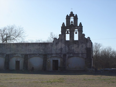 Mission San Juan was also built in 1731. I loved the bell towers which are still in use.
 The San Jose Mission is noted for its beautiful "Rose Window", an example of Spanish Colonial ornamention. It is said to be carved by Pedro Huizar in honour of his sweetheart, Rosa, who was lost at sea while on her way from Spain to join him. The less romantic theory is that it was named after Saint Rose of Lima, the first saint of the New World. I like the first theory better.
 Mission San Jose, established in 1720, was one of the most prosperous. The church itself was completed in 1782. At that time 350 Indians were living in 84 two-room apartments which lined the walls of the compound. The entire mission including the grist mill and granary have been restored.
 Paintings on the exterior of the mission have faded, but the interior wall and ceiling paintings have retained their colour and beauty.
 I made Ted go on a mission tour. There are 5 missions in San Antonio including the Alamo (Mission San Antonio de Valero) and most still hold religious services. I managed to see all but one (I didn't want to push my luck!!). The one pictured above is Mission Concepcion. Built in 1731, it is the oldest un-restored stone church in the U.S.
 February 24 - We paid a visit to the North Star Mall in San Antonio, and like everything else in Texas, the cowboy boots are bigger!!
 HemisFair Park was built for the 1968 World's Fair and is now a great park filled with waterfalls, fountains and beautiful gardens.
 The view of downtown San Antonio from the observation level of the Tower.
 The Tower of the Americas - a 750 foot tower that was built for the HemisFair in 1968. We went up 500 feet in a glass-walled elevator to the restaurant and observation level. Back on ground level, we enjoyed a 4-D movie, "Skies Over Texas". It was great - instead of the usual 3-D, our chairs actually rocked while we went bull riding, a blast of air made us think a rattlesnake had just slithered past our legs and when a longhorn steer shook its head and sprayed drool, we actually felt droplets of water on our faces. Yuck!!!
 What a great way to spend the day!
 The river and canals of the "American Venice" wind for almost two and a half miles under a series of bridges which allow pedestrians to cross from one side of the river to the other. They actually drain the river/canals once a year (I thought they were kidding at first) at the annual Mud Festival to remove some of the debris that collects during the year.
 We went on the River Walk boat cruise and really enjoyed seeing historic buildings, gargoyles, the Rivercenter Mall (above) and a real-life wedding in progress.
 This is the famous River Walk (Paseo del Rio) of San Antonio. Located one level below the downtown streets, it is a series of walkways along the San Antonio River lined with hotels, art and gift shops, boutiques, restaurants and sidewalk cafes. Things move at a much slower pace than on the busy streets above, but it is easy to go back and forth between the two.
 In honour of the anniversary celebrations, re-enactments of the siege took place. It gave us quite a start to look over our shoulders as we walked down to the River Walk and see men aiming their "rifles" at us.
 These are the grounds of the Alamo which was originally a mission when it was built in 1724. It became a military post in the early 1800s.
 February 23 - You can't pay a visit to San Antonio and not visit the Alamo. It was extremely busy the day we were there as they were celebrating the 172nd anniversary of the first day of the 13-day siege in 1836. Less than 200 Texians and Tejanos managed to hold off over 1500 Mexicans until March 6, 1836 when nearly all the defenders of the Alamo were killed including knife fighter Jim Bowie and frontiersman Davy Crockett. The Alamo became a symbol of a heroic struggle against overwhelming odds and Sam Houston is said to have shouted "Remember the Alamo!" as he led the Texans to victory over the Mexicans at San Jacinto on April 21st.
 You know you're in Texas when you see longhorn cattle grazing in the pastures. This was definitely ranching country.
 One poor lonely tree and a few shrubs managed to grow at the top
 We finally reached the top and couldn't believe our bad luck - the batteries in our camera were totally dead. We couldn't even get one picture, but then we were fortunate to meet a couple and their daughter from Dallas and they were kind enough to take our pictures and email them to us. We really appreciate their kindness. Thank you, Lynne, for proving that we made it to the top. What a view!!
 It was a fairly steep climb up the Summit Trail - 485 feet in half a mile, but we made it to the top and the view was totally worth it.
 From Luckenbach we drove to Enchanted Rock State Natural Area, the large hill you can see in the picture. Enchanted Rock is a pink granite dome that rises 425 feet above the surrounding countryside. The Tonkawa Indians named it believing that ghost fires flickered at the top on moonlit nights. It was said to be the site of human sacrifices so while some tribes used it as a gathering place, others feared it and refused to set foot on it. Others said a Spanish conquistador had cast a spell on it. Whatever the truth might be, it is considered to be a place of awe and wonder.
 Walk across a bridge from the store and you'll find a large open area beside the river where guys were setting up tents for the free dance they were holding that evening. We had to stop at the concession and have a dill pickle on a stick and sopapillas with honey. I know it's a weird combination, but boy, was it good!
 This is the side of the "outhouse". If you look closely, you can find license plates from Alberta and Saskatchewan!
 February 21 - Luckenbach, TX. We didn't see Willie or Waylon, but we were lucky to find a group of local musicians singing country songs and telling stories. Luckenbach is a small town (pop ~25) with a general store/tavern and dance hall. The town, founded in 1849 as a trading post, was bought by Hondo Crouch in 1970 for $30,000 when he saw it offered for sale in a newspaper. It's a great place to hear country music - by both well-known talent and those who just like to jam for the thousands of visitors Luckenbach receives each year.
  On our hike we found a place where we could tether our horses, but we settled for resting in the shade instead. Horses were allowed in the park and people had to yield the trail to them.
 Here you can see the high limestone bluffs along the river. This park is a great place to swim, hike, fish, picnic or go tubing.
 February 21 - Although the Guadalupe River ran just west of our campground, we drove a few miles and spent the afternoon at Guadalupe River State Park. In places it was extremely shallow; the drought the southern states is experiencing is very obvious when you see the rivers here. The water is incredibly clear - you can see the fish swimming by. You can see a variety of trees, too - giant bald cypress, oak, pecan and elm.
 This formation is known as the King's Throne. I wish we could show you these in 3-D; pictures don't do them justice.
 Welcome to Sherwood Forest. The columns looked like a forest of trees, hence the name!
 This is our guide, Becca. At this point we were about 180 feet below the surface and behind her is Purgatory Creek which reaches a depth of 211 feet. The colours in the Cavern were not as brilliant as those at Luray Caverns, VA, but we found the tour to be more informative.
 February 20 - Close to our campground just outside of New Braunfels, TX is the Natural Bridge Caverns named after the natural bridge you see above. We walked for half a mile underground surrounded by amazing stalactites, stalagmites, columns, etc. It was discovered in 1960 by 4 college students from St. Mary's College in San Antonio.
 February 29 - Oil and gas wells dotted the landscape north of Fort Stockton. Wind power and fossil fuels - western Texas is making use of both.
 February 28 - On our way to New Mexico, we saw hundreds of wind turbines, most of them on top of mesas. These were located just east of Fort Stockton and reminded us of Fort Macleod and Pincher Creek.
 After showing you beautiful historic buildings, we thought we should show you a contemporary one. This house was on the other side of the Guadalupe River from the road to our campground and everytime we went by we remarked on how unique (??) it was. We finally had to take a closer look and decided we really didn't want to be on the top floor during a windstorm. If nothing else, it must have a great view. Looks like a giant treehouse, doesn't it?
 Mission San Juan was also built in 1731. I loved the bell towers which are still in use.
 The San Jose Mission is noted for its beautiful "Rose Window", an example of Spanish Colonial ornamention. It is said to be carved by Pedro Huizar in honour of his sweetheart, Rosa, who was lost at sea while on her way from Spain to join him. The less romantic theory is that it was named after Saint Rose of Lima, the first saint of the New World. I like the first theory better.
 Mission San Jose, established in 1720, was one of the most prosperous. The church itself was completed in 1782. At that time 350 Indians were living in 84 two-room apartments which lined the walls of the compound. The entire mission including the grist mill and granary have been restored.
 Paintings on the exterior of the mission have faded, but the interior wall and ceiling paintings have retained their colour and beauty.
 I made Ted go on a mission tour. There are 5 missions in San Antonio including the Alamo (Mission San Antonio de Valero) and most still hold religious services. I managed to see all but one (I didn't want to push my luck!!). The one pictured above is Mission Concepcion. Built in 1731, it is the oldest un-restored stone church in the U.S.
 February 24 - We paid a visit to the North Star Mall in San Antonio, and like everything else in Texas, the cowboy boots are bigger!!
 HemisFair Park was built for the 1968 World's Fair and is now a great park filled with waterfalls, fountains and beautiful gardens.
 The view of downtown San Antonio from the observation level of the Tower.
 The Tower of the Americas - a 750 foot tower that was built for the HemisFair in 1968. We went up 500 feet in a glass-walled elevator to the restaurant and observation level. Back on ground level, we enjoyed a 4-D movie, "Skies Over Texas". It was great - instead of the usual 3-D, our chairs actually rocked while we went bull riding, a blast of air made us think a rattlesnake had just slithered past our legs and when a longhorn steer shook its head and sprayed drool, we actually felt droplets of water on our faces. Yuck!!!
 What a great way to spend the day!
 The river and canals of the "American Venice" wind for almost two and a half miles under a series of bridges which allow pedestrians to cross from one side of the river to the other. They actually drain the river/canals once a year (I thought they were kidding at first) at the annual Mud Festival to remove some of the debris that collects during the year.
 We went on the River Walk boat cruise and really enjoyed seeing historic buildings, gargoyles, the Rivercenter Mall (above) and a real-life wedding in progress.
 This is the famous River Walk (Paseo del Rio) of San Antonio. Located one level below the downtown streets, it is a series of walkways along the San Antonio River lined with hotels, art and gift shops, boutiques, restaurants and sidewalk cafes. Things move at a much slower pace than on the busy streets above, but it is easy to go back and forth between the two.
 In honour of the anniversary celebrations, re-enactments of the siege took place. It gave us quite a start to look over our shoulders as we walked down to the River Walk and see men aiming their "rifles" at us.
 These are the grounds of the Alamo which was originally a mission when it was built in 1724. It became a military post in the early 1800s.
 February 23 - You can't pay a visit to San Antonio and not visit the Alamo. It was extremely busy the day we were there as they were celebrating the 172nd anniversary of the first day of the 13-day siege in 1836. Less than 200 Texians and Tejanos managed to hold off over 1500 Mexicans until March 6, 1836 when nearly all the defenders of the Alamo were killed including knife fighter Jim Bowie and frontiersman Davy Crockett. The Alamo became a symbol of a heroic struggle against overwhelming odds and Sam Houston is said to have shouted "Remember the Alamo!" as he led the Texans to victory over the Mexicans at San Jacinto on April 21st.
 You know you're in Texas when you see longhorn cattle grazing in the pastures. This was definitely ranching country.
 One poor lonely tree and a few shrubs managed to grow at the top
 We finally reached the top and couldn't believe our bad luck - the batteries in our camera were totally dead. We couldn't even get one picture, but then we were fortunate to meet a couple and their daughter from Dallas and they were kind enough to take our pictures and email them to us. We really appreciate their kindness. Thank you, Lynne, for proving that we made it to the top. What a view!!
 It was a fairly steep climb up the Summit Trail - 485 feet in half a mile, but we made it to the top and the view was totally worth it.
 From Luckenbach we drove to Enchanted Rock State Natural Area, the large hill you can see in the picture. Enchanted Rock is a pink granite dome that rises 425 feet above the surrounding countryside. The Tonkawa Indians named it believing that ghost fires flickered at the top on moonlit nights. It was said to be the site of human sacrifices so while some tribes used it as a gathering place, others feared it and refused to set foot on it. Others said a Spanish conquistador had cast a spell on it. Whatever the truth might be, it is considered to be a place of awe and wonder.
 Walk across a bridge from the store and you'll find a large open area beside the river where guys were setting up tents for the free dance they were holding that evening. We had to stop at the concession and have a dill pickle on a stick and sopapillas with honey. I know it's a weird combination, but boy, was it good!
 This is the side of the "outhouse". If you look closely, you can find license plates from Alberta and Saskatchewan!
 February 21 - Luckenbach, TX. We didn't see Willie or Waylon, but we were lucky to find a group of local musicians singing country songs and telling stories. Luckenbach is a small town (pop ~25) with a general store/tavern and dance hall. The town, founded in 1849 as a trading post, was bought by Hondo Crouch in 1970 for $30,000 when he saw it offered for sale in a newspaper. It's a great place to hear country music - by both well-known talent and those who just like to jam for the thousands of visitors Luckenbach receives each year.
  On our hike we found a place where we could tether our horses, but we settled for resting in the shade instead. Horses were allowed in the park and people had to yield the trail to them.
 Here you can see the high limestone bluffs along the river. This park is a great place to swim, hike, fish, picnic or go tubing.
 February 21 - Although the Guadalupe River ran just west of our campground, we drove a few miles and spent the afternoon at Guadalupe River State Park. In places it was extremely shallow; the drought the southern states is experiencing is very obvious when you see the rivers here. The water is incredibly clear - you can see the fish swimming by. You can see a variety of trees, too - giant bald cypress, oak, pecan and elm.
 This formation is known as the King's Throne. I wish we could show you these in 3-D; pictures don't do them justice.
 Welcome to Sherwood Forest. The columns looked like a forest of trees, hence the name!
 This is our guide, Becca. At this point we were about 180 feet below the surface and behind her is Purgatory Creek which reaches a depth of 211 feet. The colours in the Cavern were not as brilliant as those at Luray Caverns, VA, but we found the tour to be more informative.
 February 20 - Close to our campground just outside of New Braunfels, TX is the Natural Bridge Caverns named after the natural bridge you see above. We walked for half a mile underground surrounded by amazing stalactites, stalagmites, columns, etc. It was discovered in 1960 by 4 college students from St. Mary's College in San Antonio.

No comments:
Post a Comment