Howdy, y'all! Welcome to the Lone Star State! Sorry it's been awhile - lots to see and do in Texas. We are now officially known as "Winter Texans". In case you forgot, most recent entries at the top, captions below the entries.  Boca Chica Beach - an undeveloped 7.5 miles of beach where the Rio Grande flows into the Gulf of Mexico. Unfortunately we were there at high tide and the beach disappeared so we couldn't reach the actual spot where the two meet. Next time!!
  February 18 - Palo Alto Battlefield National Historic Site - A two-year war between the United States and Mexico over who held jurisdiction over the Republic of Texas began here on May 8, 1846. Although the Mexican army was much larger, the U.S. cannons caused a greater loss of life to the Mexican army. The Mexicans withdrew and the U.S. claimed victory at Resaca de la Palma the next day. The U.S. went on to win the war and the Rio Grande became the border between the two countries. Texas has had six flags fly over it - Spain, France, Mexico, Republic of Texas, the Confederacy and the U.S. - since it was first explored by Cortez in 1519.
 The bridge we crossed on our way back to Brownsville. Unfortunately we took the first bridge we came to and it turned out to be the B & M (which runs east/west), not the International (which runs north/south). We got through Customs, walked out the door, looked around and realized that we didn't have a clue where we were. We had to walk another mile in the blazing heat to get back to our truck. Next time we'll read the map more closely! Got our exercise that day!
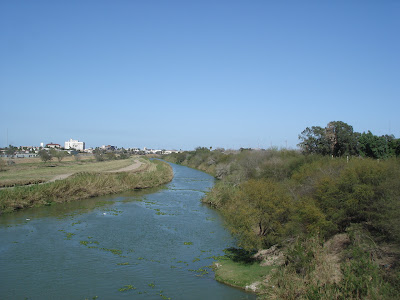 The Rio Grande River - the longest river in Texas and the border between Mexico and the U.S. We saw lots of border patrols. Ted was even stopped one day when he took the dogs for a walk by our campground. They let him go when they realized he might be an alien, but he wasn't illegal.
 We took a break from browsing to have a cold one and a great lunch of tacos, tamales, burritos and other tasty items whose names I cannot recall. Cheers (or whatever the word is in Spanish)!
 February 17 - Being so close to Mexico we decided to walk across the International Bridge from Brownsville to Matamoros. We walked to the Juarez Market - about 1.5 miles in +30 heat. It was a busy market stretching for several blocks selling everything you can imagine.
 I'm not sure whose murals came first - Moose Jaw or Harlingen - but Harlingen is the mural capital of South Texas having more then 30 on display at various locations.
 February 16 - Harlingen - location of the Marine Military Academy and home to the original working model of the Iwo Jima Memorial statue found at Arlington Cemetery in Washington, DC. It was donated to the school by the sculptor, Dr. Felix W. de Weldon. The man depicted on the statue pushing the flag into the rocks was actually a local boy, Cpl. Harlan Block, who was killed a few weeks after the famous photo was taken. His remains are now buried a few yards from the statue.
 Port of Brownsville - a busy seaport where one company (Keppel Fels) designs, constructs and repairs offshore drilling rigs. It was strange to see one on land and not floating offshore.
 From the top of the lighthouse we could see across Lagune Madre to South Padre Island.
 On the way back to Brownsville, we stopped at the lighthouse at Port Isabel. This is my last lighthouse, I promise!! It was built in 1852 and used until 1905.
 You might see one of these but it will be pushing snow, not sand!
 You don't see this sign at home!!
 This was the end of the road on South Padre. To the north is Padre Island National Seashore which cannot be accessed by road, bridge or ferry from this end although it is accessible from North Padre Island. The south end of this island is filled with hotels, restaurants and condos but the north end is entirely natural and on the beach you can drive your vehicles or ride horses.
 February 14 - South Padre Island. Instead of fences, they use bales to hold back the sand from drifting onto the road.
 Brownsville, TX - This is the view from our camp site at River Bend campground. It is situated on a golf course right beside the Rio Grande River so we were right across the river from Mexico. To our left is the 3rd hole, to our right is the 6th hole and straight ahead is the driving range. Too bad we don't golf much!!
 February 12 - and you thought Saskatchewan was flat!! This is a field just outside Kingsville located in the Wild Horse Desert. This is a huge ranching area and the location of the King Ranch which covers 825,000 acres and is home to 60,000 head of cattle and 300 quarter horses. Texas big!!!
 Regina has Mosaic Stadium at Taylor Field, Toronto has the Rogers Centre and Corpus Christi has . . . Whataburger Field!! We have to keep our fingers crossed that Burger King doesn't buy the rights to McMahon Stadium in Calgary or that Commonwealth Stadium doesn't become Taco Bell Centre!!!
 The Seawall in Corpus Christi, built in the late 1930s, has steps to the water.
 We went for a walk along Shoreline Blvd.
 February 9 - We took a walk along the bay in Corpus Christi. Moored along the pier was a huge floating hotel called the RiverBarge. It takes passengers on 4-10 day excursions up the Mississippi and Ohio Rivers. It was docked here for maintenance. It sounded like it would be a lot of fun. Behind the RiverBarge is the USS Lexington, a WWII aircraft carrier and now a floating museum.
 We stopped by one of the piers in Port Aransas and got very close to a brown pelican who was waiting to swoop in and catch fish that the fishermen threw back in the water.
 . . . it had tentacles buried beneath the sand and it stung him!! He stopped the beach patrol and they told him it was a Portuguese Man o' War and he would probably live - quite a relief for both of us. It was quite painful, however, and both the beach patrol and a pharmacist at Walgreen's (he needed a second opinion) recommended Ted put rubbing alcohol and then a paste of Adolph's meat tenderizer and water on it to reduce the swelling and pain. That will teach him to stick his foot where it's not wanted!!
 All along the beach on Mustang Island we saw these puffy balloon-like things laying on the sand. I took pictures, but Ted took it upon himself to pick them up and toss them back in the water. At one point, he actually kicked one and guess what . . .
 February 8 - We drove down to Corpus Christi and crossed the bridge to North Padre Island and Mustang Island. Beautiful white sand where you can dry camp right on the beach. We hope to do this next time we visit this part of Texas.
 We had all kinds of neighbours in the campground - even javelinas. There was a herd of about 8 that wandered the campground in search of food. They certainly showed no fear of humans. We also saw an armadillo on one of our walks but unfortunately we did not have our camera with us so you'll have to take our word for it.
 February 5 - Lake Corpus Christi State Park where we camped for a week. It is a great place for fishing and bird-watching. Texas has five of the country's top 12 bird watching sites.
 The beach, the seawall and the buildings along Seawall Blvd. See what a grey day it was! The Strand, the city's downtown, was quite beautiful with restored iron-front buildings, but most of it was blocked off because a Mardi Gras Parade had just ended and the streets had not reopened before we left.
 From the Space Centre we south drove to Galveston. I must admit I was disappointed in Galveston. The majority of buildings along the highway entering the city were run-down and badly in need of a face lift. Their last hurricane was in 1900 (claiming over 6000 lives) so that wasn't the cause. It was a blustery and overcast day so that didn't help either. Galveston is an island 30 miles long and 3 miles wide and 10 miles of seawall were built along the beach in 1902 to protect it from future hurricanes. Children have painted murals on the wall depicting underwater life which makes the seawall much more interesting.
 We stopped at Rocket Park where they had various rockets on display. This shows all 3 stages of the Saturn V rocket used as a backup for Apollo and Skylab missions. It was absolutely huge!!
 This is a replica of the Canadarm which astronauts use to practice moving payloads.
 At the Space Vehicle Mockup Facility we could see where astronauts train for their upcoming space shuttle missions.
 We took the NASA Tram Tour to the Johnson Space Center, home of the Mission Control Center, where Space Shuttle missions are monitored and directed from seconds after launch to landing. As it was a Sunday, all was quiet although we could see what was happening on the space shuttle on the video screen. It was so neat to be there. I couldn't resist the urge to whisper "Houston, we have lift-off!"
 This is a model of the Orion Crew Exploration Vehicle which NASA hopes to use to put men/women back on the moon by 2018. They refer to it as "Apollo on Steroids". It will parachute to a dry landing using air bags to cushion the landing and they hope to use it up to 9 times by replacing the heat shield after each landing. Do you think Ted has the "right stuff"?
 The Centre has more than 800 pounds of lunar rocks and soil collected during the Apollo program. I actually got to touch one!
 I always wondered what bathrooms were like on the Space Shuttle and now I know!
 Welcome to the Space Shuttle flight deck.
 This is a replica of Skylab where you can see the effects of zero gravity on a dummy.
 This is the Lunar Roving Vehicle Trainer used in training astronauts who landed on the moon.
 February 3 - More to our taste was NASA - Space Center Houston. It was amazing. Our first stop was the Starship Gallery where we saw a film about the history of the space program and then we traced its progression through actual exhibits such as the Gemini V capsule seen above. Can you imagine 2 people spinning around the earth in that? Too claustrophobic for me!
 The title of this work of art adorning a 1957 Ford Thunderbird was "Going Pac-Man". There was also a work of art in progress - a VW being painted in abstract colours with no specific theme in mind. We both felt extremely culturally uplifted after leaving this museum.
 This is one of the indoor displays - rather Mad Max, don't you think? This car was a winner at the annual Art Car Parade and had actually been driven all the way to Los Angeles and back. There was also a display of artwork on the walls by 3 local artists.
 These are two of the outdoor exhibits. Do you not find them culturally enlightening and intellectually stimulating?? Who would have thought to cover a car in sea shells - only the artsy-fartsy!!
 As you may have noticed, Ted & I are not big on museums. We prefer outdoor historical venues to those found indoors. However, when we read that Houston was the cultural capital of Texas, we thought it was time to take advantage of at least one of the many museums, theatres, galleries, etc. the city had to offer. Our choice - the Art Car Museum!!
 The skyline of downtown Houston. As it was a Saturday, the streets weren't too busy.
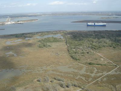 This is a view of Scott Bay which flows into Galveston Bay and the Gulf of Mexico. In the short time we were there, we saw several ships and tugboats make their way through the channel. The WWI battleship "Texas" is also located in the park, but after having just toured the "Alabama", we figured if we'd seen one battleship, we'd basically seen them all!!!
 The view of Houston from the observation tower of the monument (498' high) was incredible. This is looking west towards downtown Houston. You can see the Reflecting Pool (just like Washington, DC's), the Buffalo Bayou and the San Jacinto River. Oil storage tanks can be seen in the distance. Its petrochemical, high tech, aerospace and petroleum industries have helped make Houston a financial hub and the largest city in Texas.
 February 2 - Our first stop was the San Jacinto Battleground State Historic Park in Deer Park, just outside of Houston. This is the site where Texas won independence from Mexico on April 21, 1836. It looks like the Washington Monument with a star on top which makes it 12 feet taller. Of course, everything in Texas is bigger, even the monuments!!
 February 1 - Wallisville, TX. We loved our campground at Wallisville, about 30 miles east of Houston. It backed onto Turtle Bayou and was a beautiful, quiet place to come back to after a day of sightseeing.
 Boca Chica Beach - an undeveloped 7.5 miles of beach where the Rio Grande flows into the Gulf of Mexico. Unfortunately we were there at high tide and the beach disappeared so we couldn't reach the actual spot where the two meet. Next time!!
  February 18 - Palo Alto Battlefield National Historic Site - A two-year war between the United States and Mexico over who held jurisdiction over the Republic of Texas began here on May 8, 1846. Although the Mexican army was much larger, the U.S. cannons caused a greater loss of life to the Mexican army. The Mexicans withdrew and the U.S. claimed victory at Resaca de la Palma the next day. The U.S. went on to win the war and the Rio Grande became the border between the two countries. Texas has had six flags fly over it - Spain, France, Mexico, Republic of Texas, the Confederacy and the U.S. - since it was first explored by Cortez in 1519.
 The bridge we crossed on our way back to Brownsville. Unfortunately we took the first bridge we came to and it turned out to be the B & M (which runs east/west), not the International (which runs north/south). We got through Customs, walked out the door, looked around and realized that we didn't have a clue where we were. We had to walk another mile in the blazing heat to get back to our truck. Next time we'll read the map more closely! Got our exercise that day!
 The Rio Grande River - the longest river in Texas and the border between Mexico and the U.S. We saw lots of border patrols. Ted was even stopped one day when he took the dogs for a walk by our campground. They let him go when they realized he might be an alien, but he wasn't illegal.
 We took a break from browsing to have a cold one and a great lunch of tacos, tamales, burritos and other tasty items whose names I cannot recall. Cheers (or whatever the word is in Spanish)!
 February 17 - Being so close to Mexico we decided to walk across the International Bridge from Brownsville to Matamoros. We walked to the Juarez Market - about 1.5 miles in +30 heat. It was a busy market stretching for several blocks selling everything you can imagine.
 I'm not sure whose murals came first - Moose Jaw or Harlingen - but Harlingen is the mural capital of South Texas having more then 30 on display at various locations.
 February 16 - Harlingen - location of the Marine Military Academy and home to the original working model of the Iwo Jima Memorial statue found at Arlington Cemetery in Washington, DC. It was donated to the school by the sculptor, Dr. Felix W. de Weldon. The man depicted on the statue pushing the flag into the rocks was actually a local boy, Cpl. Harlan Block, who was killed a few weeks after the famous photo was taken. His remains are now buried a few yards from the statue.
 Port of Brownsville - a busy seaport where one company (Keppel Fels) designs, constructs and repairs offshore drilling rigs. It was strange to see one on land and not floating offshore.
 From the top of the lighthouse we could see across Lagune Madre to South Padre Island.
 On the way back to Brownsville, we stopped at the lighthouse at Port Isabel. This is my last lighthouse, I promise!! It was built in 1852 and used until 1905.
 You might see one of these but it will be pushing snow, not sand!
 You don't see this sign at home!!
 This was the end of the road on South Padre. To the north is Padre Island National Seashore which cannot be accessed by road, bridge or ferry from this end although it is accessible from North Padre Island. The south end of this island is filled with hotels, restaurants and condos but the north end is entirely natural and on the beach you can drive your vehicles or ride horses.
 February 14 - South Padre Island. Instead of fences, they use bales to hold back the sand from drifting onto the road.
 Brownsville, TX - This is the view from our camp site at River Bend campground. It is situated on a golf course right beside the Rio Grande River so we were right across the river from Mexico. To our left is the 3rd hole, to our right is the 6th hole and straight ahead is the driving range. Too bad we don't golf much!!
 February 12 - and you thought Saskatchewan was flat!! This is a field just outside Kingsville located in the Wild Horse Desert. This is a huge ranching area and the location of the King Ranch which covers 825,000 acres and is home to 60,000 head of cattle and 300 quarter horses. Texas big!!!
 Regina has Mosaic Stadium at Taylor Field, Toronto has the Rogers Centre and Corpus Christi has . . . Whataburger Field!! We have to keep our fingers crossed that Burger King doesn't buy the rights to McMahon Stadium in Calgary or that Commonwealth Stadium doesn't become Taco Bell Centre!!!
 The Seawall in Corpus Christi, built in the late 1930s, has steps to the water.
 We went for a walk along Shoreline Blvd.
 February 9 - We took a walk along the bay in Corpus Christi. Moored along the pier was a huge floating hotel called the RiverBarge. It takes passengers on 4-10 day excursions up the Mississippi and Ohio Rivers. It was docked here for maintenance. It sounded like it would be a lot of fun. Behind the RiverBarge is the USS Lexington, a WWII aircraft carrier and now a floating museum.
 We stopped by one of the piers in Port Aransas and got very close to a brown pelican who was waiting to swoop in and catch fish that the fishermen threw back in the water.
 . . . it had tentacles buried beneath the sand and it stung him!! He stopped the beach patrol and they told him it was a Portuguese Man o' War and he would probably live - quite a relief for both of us. It was quite painful, however, and both the beach patrol and a pharmacist at Walgreen's (he needed a second opinion) recommended Ted put rubbing alcohol and then a paste of Adolph's meat tenderizer and water on it to reduce the swelling and pain. That will teach him to stick his foot where it's not wanted!!
 All along the beach on Mustang Island we saw these puffy balloon-like things laying on the sand. I took pictures, but Ted took it upon himself to pick them up and toss them back in the water. At one point, he actually kicked one and guess what . . .
 February 8 - We drove down to Corpus Christi and crossed the bridge to North Padre Island and Mustang Island. Beautiful white sand where you can dry camp right on the beach. We hope to do this next time we visit this part of Texas.
 We had all kinds of neighbours in the campground - even javelinas. There was a herd of about 8 that wandered the campground in search of food. They certainly showed no fear of humans. We also saw an armadillo on one of our walks but unfortunately we did not have our camera with us so you'll have to take our word for it.
February 5 - Lake Corpus Christi State Park where we camped for a week. It is a great place for fishing and bird-watching. Texas has five of the country's top 12 bird watching sites.
We had all kinds of neighbours in the campground - even javelinas. There was a herd of about 8 that wandered the campground in search of food. They certainly showed no fear of humans. We also saw an armadillo on one of our walks but unfortunately we did not have our camera with us so you'll have to take our word for it.
February 5 - Lake Corpus Christi State Park where we camped for a week. It is a great place for fishing and bird-watching. Texas has five of the country's top 12 bird watching sites.
 The beach, the seawall and the buildings along Seawall Blvd. See what a grey day it was! The Strand, the city's downtown, was quite beautiful with restored iron-front buildings, but most of it was blocked off because a Mardi Gras Parade had just ended and the streets had not reopened before we left.
 From the Space Centre we south drove to Galveston. I must admit I was disappointed in Galveston. The majority of buildings along the highway entering the city were run-down and badly in need of a face lift. Their last hurricane was in 1900 (claiming over 6000 lives) so that wasn't the cause. It was a blustery and overcast day so that didn't help either. Galveston is an island 30 miles long and 3 miles wide and 10 miles of seawall were built along the beach in 1902 to protect it from future hurricanes. Children have painted murals on the wall depicting underwater life which makes the seawall much more interesting.
 We stopped at Rocket Park where they had various rockets on display. This shows all 3 stages of the Saturn V rocket used as a backup for Apollo and Skylab missions. It was absolutely huge!!
 This is a replica of the Canadarm which astronauts use to practice moving payloads.
 At the Space Vehicle Mockup Facility we could see where astronauts train for their upcoming space shuttle missions.
 We took the NASA Tram Tour to the Johnson Space Center, home of the Mission Control Center, where Space Shuttle missions are monitored and directed from seconds after launch to landing. As it was a Sunday, all was quiet although we could see what was happening on the space shuttle on the video screen. It was so neat to be there. I couldn't resist the urge to whisper "Houston, we have lift-off!"
 This is a model of the Orion Crew Exploration Vehicle which NASA hopes to use to put men/women back on the moon by 2018. They refer to it as "Apollo on Steroids". It will parachute to a dry landing using air bags to cushion the landing and they hope to use it up to 9 times by replacing the heat shield after each landing. Do you think Ted has the "right stuff"?
 The Centre has more than 800 pounds of lunar rocks and soil collected during the Apollo program. I actually got to touch one!
 I always wondered what bathrooms were like on the Space Shuttle and now I know!
 Welcome to the Space Shuttle flight deck.
 This is a replica of Skylab where you can see the effects of zero gravity on a dummy.
 This is the Lunar Roving Vehicle Trainer used in training astronauts who landed on the moon.
 February 3 - More to our taste was NASA - Space Center Houston. It was amazing. Our first stop was the Starship Gallery where we saw a film about the history of the space program and then we traced its progression through actual exhibits such as the Gemini V capsule seen above. Can you imagine 2 people spinning around the earth in that? Too claustrophobic for me!
 The title of this work of art adorning a 1957 Ford Thunderbird was "Going Pac-Man". There was also a work of art in progress - a VW being painted in abstract colours with no specific theme in mind. We both felt extremely culturally uplifted after leaving this museum.
 This is one of the indoor displays - rather Mad Max, don't you think? This car was a winner at the annual Art Car Parade and had actually been driven all the way to Los Angeles and back. There was also a display of artwork on the walls by 3 local artists.
 These are two of the outdoor exhibits. Do you not find them culturally enlightening and intellectually stimulating?? Who would have thought to cover a car in sea shells - only the artsy-fartsy!!
 As you may have noticed, Ted & I are not big on museums. We prefer outdoor historical venues to those found indoors. However, when we read that Houston was the cultural capital of Texas, we thought it was time to take advantage of at least one of the many museums, theatres, galleries, etc. the city had to offer. Our choice - the Art Car Museum!!
 The skyline of downtown Houston. As it was a Saturday, the streets weren't too busy.
 This is a view of Scott Bay which flows into Galveston Bay and the Gulf of Mexico. In the short time we were there, we saw several ships and tugboats make their way through the channel. The WWI battleship "Texas" is also located in the park, but after having just toured the "Alabama", we figured if we'd seen one battleship, we'd basically seen them all!!!
 The view of Houston from the observation tower of the monument (498' high) was incredible. This is looking west towards downtown Houston. You can see the Reflecting Pool (just like Washington, DC's), the Buffalo Bayou and the San Jacinto River. Oil storage tanks can be seen in the distance. Its petrochemical, high tech, aerospace and petroleum industries have helped make Houston a financial hub and the largest city in Texas.
 February 2 - Our first stop was the San Jacinto Battleground State Historic Park in Deer Park, just outside of Houston. This is the site where Texas won independence from Mexico on April 21, 1836. It looks like the Washington Monument with a star on top which makes it 12 feet taller. Of course, everything in Texas is bigger, even the monuments!!
 February 1 - Wallisville, TX. We loved our campground at Wallisville, about 30 miles east of Houston. It backed onto Turtle Bayou and was a beautiful, quiet place to come back to after a day of sightseeing.
2 comments:
Hi !.
You re, I guess , perhaps curious to know how one can make real money .
There is no initial capital needed You may begin to receive yields with as small sum of money as 20-100 dollars.
AimTrust is what you need
The company incorporates an offshore structure with advanced asset management technologies in production and delivery of pipes for oil and gas.
It is based in Panama with structures around the world.
Do you want to become really rich in short time?
That`s your chance That`s what you really need!
I feel good, I began to take up income with the help of this company,
and I invite you to do the same. If it gets down to choose a proper companion who uses your funds in a right way - that`s the AimTrust!.
I earn US$2,000 per day, and what I started with was a funny sum of 500 bucks!
It`s easy to join , just click this link http://gasiwoga.lookseekpages.com/ohuxih.html
and lucky you`re! Let`s take our chance together to become rich
Hi There I'd love to congratulate you for such a terrific made site!
Was thinking this would be a nice way to introduce myself!
Sincerely,
Robin Toby
if you're ever bored check out my site!
[url=http://www.partyopedia.com/articles/mardi-gras-party-supplies.html]mardi gras Party Supplies[/url].
Post a Comment